It’s a bird … it’s a plane …
Published 7:36 pm Saturday, August 2, 2014
TOMMY MOBLEY | CONTRIBUTED
JACK’S CREEK: The neighborhood around Jack’s Creek in Washington looks much like a village in miniature in this photo
Washington photographer offers an unusual perspective
Washington native Tommy Mobley is getting a bird’s eye view of the local landscape from a pretty interesting perspective.
TOMMY MOBLEY | CONTRIBUTED
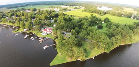
BEAUTIFUL BATH: This photo offers a bird’s eye view of the pristine beauty of Bath’s Bonner Point.
Using a DJI Phantom Vision drone, Mobley is recording video and snapping still photos high above the heads of Beaufort County residents. Mobley purchased the remote-controlled drone, which is just a little bigger than a child’s radio airplane, last September. Scarcely a day goes by when he doesn’t have it airborne, soaring high above the cityscape and the waters of the Pamlico River. He trained himself in the operation of the craft with just a few pitfalls along the way. He crashed it the very first day, and a couple of times he’s launched the drone in hopes of capturing some unusual photos, only to find the memory card was full or missing.
Nevertheless, Mobley has some spectacular images to share, many of which can be found on his “East NC Aerial Photography” Facebook page. He’s taken photos all over Washington, and he recently took the craft to Bath and plans to visit Belhaven.
TOMMY MOBLEY | CONTRIBUTED
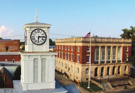
HISTORY: Mobley’s photo features two local landmarks, the clock atop the old courthouse and Washington’s municipal building.
The battery-operated drone has a maximum distance of 1,200 feet, and by law Mobley is required to keep it at an altitude of 400 feet or less. It can travel up to 35 miles per hour, depending on the wind, and Mobley can operate it for approximately 25 minutes before recharging the battery.
One of his most interesting forays was during Washington’s fireworks display earlier this summer; that was the time he realized he’d left the memory card home and couldn’t take photos. But he did entertain bystanders.
“It caught a lot of people’s attention,” Mobley said, noting that the drone’s red and green lights make it resemble an unidentified flying object at night. “They’re really bright lights so it definitely freaked some people out.”
TOMMY MOBLEY | CONTRIBUTED
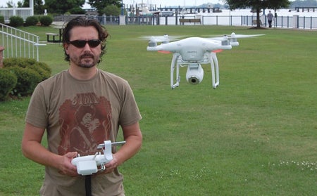
LIFT OFF: Tommy Mobley launches his drone along the Washington waterfront.
Mobley enjoys using the drone for his own entertainment, but the artist in him wants to share the photos. A guitar player and painter, he plans to print and market some of his better shots. Already, he’s received a request from a former Washington resident who wants a memento of his old hometown. He’s also launching a website and through that he will advertise his services of providing aerial views of local farms, homes, businesses and neighborhoods.
Mobley and his drone have already found some rather odd admirers. The craft has drawn attention from black birds and sea gulls, who have pursued it on several occasions, Mobley shared with a laugh.
The photos he’s amassed since first launching the drone have brought him pleasure and that is what interests him most.
“If there was no camera on it, I’d have already been bored with it,” he said.
*For more information about Mobley and his drone photos, call 252-943-1118.
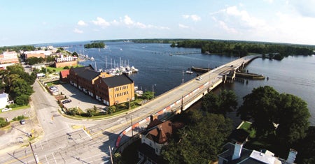
TOMMY MOBLEY | CONTRIBUTED
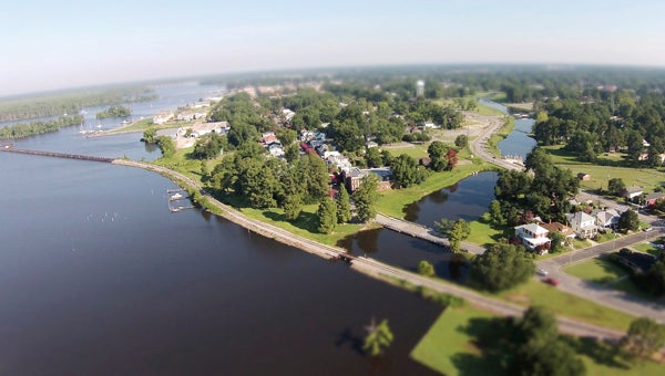
WATER VIEW: This photo captures a view of the Pamlico and Tar rivers along the N.C. Highway 17 bridge.
More News


-
Polls
 Loading ...
-
-