NOAA puts focus on storm surge this hurricane season
Published 9:23 pm Monday, June 1, 2015
NATIONAL OCEANIC AND ATMOSPHERIC ADMINISTRATION
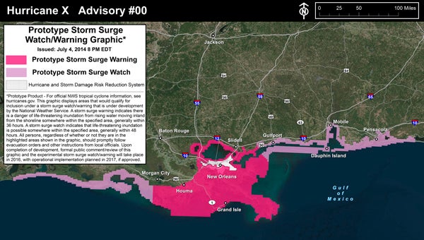
WARNING: National Oceanic and Atmospheric Administration will use graphics like this one to identify areas likely to be threatened by significant storm surge during any major storm this hurricane season.
In case you missed it, the 2015 Atlantic Ocean hurricane season began Monday.
The Atlantic hurricane season runs from June 1 to Nov. 30 of each year.
There’s already been one named storm this spring — Ana. The remnants of that tropical storm passed by the North Carolina coast in early May.
The remaining names for tropical storms or hurricanes this year are Bill, Claudette, Danny, Erika, Fred, Grace, Henri, Ida, Joaquin, Kate, Larry, Mindy, Nicholas, Odette, Peter, Rose, Sam, Teresa, Victor and Wanda. Should other names are needed, those names would come from the Greek alphabet — Alpha, Beta and so on.
For the 2015 Atlantic hurricane season, the National Oceanic and Atmospheric Administration predicts a 70-percent likelihood of six to 11 named storms (winds of 39 mph or higher), of which three to six storms could become hurricanes (winds of at least 74 mph). NOAA predicts up to two storms could become major hurricanes (categories 3, 4 and 5). Overall, NOAA expects a below-normal hurricane season.
“A below-normal season doesn’t mean we’re off the hook. As we’ve seen before, below-normal seasons can still produce catastrophic impacts to communities,” said NOAA Administrator Kathryn Sullivan, Ph.D., referring to the 1992 season in which only seven named storms formed, yet the first was Andrew – a Category 5 major hurricane that devastated South Florida.
“The main factor expected to suppress the hurricane season this year is El Niño, which is already affecting wind and pressure patterns, and is forecast to last through the hurricane season,” said Gerry Bell, Ph.D., lead seasonal hurricane forecaster with NOAA’s Climate Prediction Center. “El Niño may also intensify as the season progresses, and is expected to have its greatest influence during the peak months of the season. We also expect sea surface temperatures in the tropical Atlantic to be close to normal, whereas warmer waters would have supported storm development.”
This hurricane season, NOAA is using new storm-surge watch/warning graph intended to highlight areas along the Atlantic and Gulf of Mexico coasts that face significant life-threatening risks from storm surge.
“Storm surge is often the greatest threat to life and property from a tropical cyclone, and it can occur at different times and at different locations from a storm’s hazardous winds. In addition, while most coastal residents can remain in their homes and be safe from a tropical cyclone’s winds, evacuations are often needed to keep people safe from storm surge. Having separate warnings for these two hazards should provide emergency managers, the media, and the general public better guidance on the hazards they face when tropical cyclones threaten,” reads the NOAA website.
Two years ago, area emergency-management officials and media representatives participated in a meeting that focused on storm surge. The meeting was held at the North Carolina Estuarium.
John Pack, Beaufort County’s emergency-services director, said at that meeting many Aurora-area residents learned a lesson about storm surge when Hurricane Irene came up the North Carolina coast in 2011.
“Several years ago, the hurricane center became quite interested in trying to figure out how to do a better job of doing storm-surge forecasting, but also storm-surge communication,” said Betty Morrow, one of the NOAA officials at that meeting. “We started doing surveys to see if people understood storm surge. We found, in general, they do not.”
About Mike Voss
Mike Voss is the contributing editor at the Washington Daily News. He has a daughter and four grandchildren. Except for nearly six years he worked at the Free Lance-Star in Fredericksburg, Va., in the early to mid-1990s, he has been at the Daily News since April 1986.
Journalism awards:
• Pulitzer Prize for Meritorious Public Service, 1990.
• Society of Professional Journalists: Sigma Delta Chi Award, Bronze Medallion.
• Associated Press Managing Editors’ Public Service Award.
• Investigative Reporters & Editors’ Award.
• North Carolina Press Association, First Place, Public Service Award, 1989.
• North Carolina Press Association, Second Place, Investigative Reporting, 1990.
All those were for the articles he and Betty Gray wrote about the city’s contaminated water system in 1989-1990.
• North Carolina Press Association, First Place, Investigative Reporting, 1991.
• North Carolina Press Association, Third Place, General News Reporting, 2005.
• North Carolina Press Association, Second Place, Lighter Columns, 2006.
Recently learned he will receive another award.
• North Carolina Press Association, First Place, Lighter Columns, 2010.
4. Lectured at or served on seminar panels at journalism schools at UNC-Chapel Hill, University of Maryland, Columbia University, Mary Washington University and Francis Marion University.
 More by Mike
More News


-
Polls
 Loading ...
-
-