Latest estimates show fire covers less than 10,000 acres
Published 6:44 pm Friday, April 22, 2016
INCIWEB
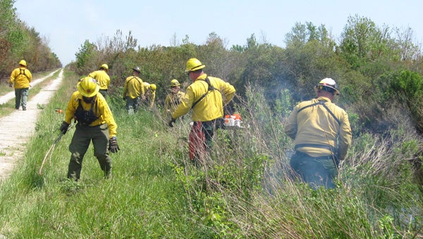
NEW NUMBERS: The Whipping Creek Fire nears a canal along U.S. Highway 264. Recent estimates show the fire covers 9,780 acres. N.C. Forest Service crews prepare for a pumping operation along U.S. Highway 264.
New estimates show a Hyde County wildfire has covered less area than originally thought.
The Whipping Creek Fire is estimated to cover 9,780 acres as of Friday afternoon, according to a press release. It remains at 15-percent containment.
“Accurate mapping of the fire yesterday caused the fire footprint to be downsized over 4,000 acres. Fire manager’s suppression plans continue to hold the fire south of Jackson and Maple Roads as contingency lines; however, the western flank of the fire is still south of Whipping Creek Road,” the release stated.
Crews suspected the fire to have engulfed about 14,000 acres as of Thursday evening. Bill Swartley, public information officer of the Incident Command Post Fire Information Center, said it was difficult to get an accurate number due to the dense smoke, and it was possible the number could be higher than 14,000.
The areas affected include N.C. Wildlife Resources Commission game lands, Alligator River National Wildlife Refuge, U.S. Air Force property and the Nature Conservancy.
N.C. Forest Service is working to improve Whipping Creek Road as a firebreak, according to the release. A firebreak is usually enhanced by removing more vegetation down to the soil, or widening a road’s surface area to create a larger barrier.
About a 30-mile stretch along U.S. Highway 264, between Stumpy Point and Engelhard, remains closed, and drivers are being rerouted to N.C. Highway 94 toward Columbia and east on U.S. Highway 64.
“We are looking at a plan to get that open,” Swartley said. “I don’t know whether there will be a change in the status of the (road) closure. … The fire is still present. It’s just removed where you can’t get to it off the paved road.”
The N.C. Department of Environmental Quality also issued an advisory for air pollution from the smoke. The air quality report for Hyde and Dare counties is listed as “Code Orange” for the weekend, while Tyrrell County remains at “Code Yellow.”
The Whipping Creek Fire is the largest of three wildfires blazing within the state. A fire in Brunswick County has burned about 1,600 acres and a fire near the North Carolina-Tennessee border has burned about 800 acres, according to reports from The Associated Press.
“Increased cloud cover, higher humidity, and periodic rain showers or thunderstorms will be working against the fire. However, forecasted gusty winds from the southwest could overcome these weather obstacles and speed the fire’s growth to the north and east,” the release stated Friday.
Swartley said crews are hoping to have some help from the rain, and rain gauges are set up at fire sites to determine exact amounts. The main concern at this point is damage to power poles and guardrails, he said.
“It is certainly a different day,” Swartley said of what he saw Friday evening.
He said there are still no direct threats to communities, as the fire is mostly affecting uninhabited forestland.
For the latest updates over the weekend, visit www.thewashingtondailynews.com.
More News


-
Polls
 Loading ...
-
-