Experts share information on safe boating at night
Published 6:09 pm Friday, June 22, 2018
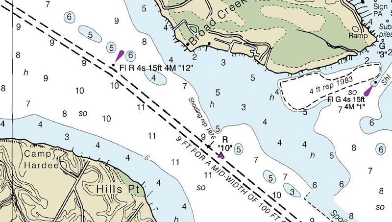
- READING A CHART: Using a chart can be especially helpful in understanding one’s position in the river at night. For example, the purple arrow on the left-hand side of this chart marks the position of a flashing red marker, No. 12. The purple triangle further along the channel is an unlit red marker, No. 10. (NOAA)
Boating at night can be a beautiful experience. Between the tranquility of the waters and the unparalleled opportunities for stargazing, the river can be a place of solace in a busy world.
Yet, for the uninformed, navigating the waters of the Pamlico and Pungo rivers at night can easily become a hazardous endeavor. With the summer season in full swing, boat traffic is steadily increasing, and understanding how to properly navigate one’s vessel is of the utmost importance.
Especially critical to nighttime navigation are the lit channel markers that allow vessels to navigate the river under the stars. With red or green lights flashing at different increments, skilled boaters can easily determine their position on the river.
While not every marker in the Pamlico is lit, the illuminated markers are generally placed within eyeshot of one another.
According to U.S. Coast Guard Chief Nathan Jones, at USCG Station Hobucken, unlit markers, called day markers, remain unlit because multiple lit markers might cause confusion for boaters navigating at night.
“A practice that we use is when we navigate any body of water, we always have a corrected chart for that area,” Jones said. “Having that chart as a visual reference will also aid in safe navigation, especially if you are unfamiliar as an area.”
In addition to the flashing red or green lights associated with channel markers, Washington waterfront docks Dockmaster Rick Brass says that other common lights include flashing white and yellow lights, which mark destinations and hazards, respectively.
For example, flashing white lights mark Pamlico Point and Willow Point as destinations for boaters. At Brant Island Shoals, in the Pamlico Sound between the Pamlico and the Bay rivers, yellow lights mark a U.S. Marine Corps bombing range.
“I tell people sometimes that navigating at night is like playing connect the dots with the flashing lights,” Brass said. “By looking at the color and flash pattern you can pretty much figure out where you are on the chart.”
To ensure safe navigation, boaters can take a few simple steps to ensure the safety of themselves and others:
- Make sure to have an updated chart aboard the vessel. A chart is a vital resource for any boater, offering information regarding navigational aids and potential hazards. Regular updates ensure that the latest information is available.
- Boaters should familiarize themselves with the symbols and markings that are commonly used on charts. The National Oceanic and Atmospheric Association’s “U.S. Chart No. 1” comes highly recommended by both Jones and Brass as the place to start for learning proper navigation.
- Ensure vessels are equipped with proper navigational lights. Under North Carolina state law, a vessel is required to use navigational lights when away from the dock between sunset and sunrise, as well as in conditions of restricted visibility. A spotlight is also recommended to light the area ahead of the boat.
- Practice situational awareness. Be aware of hazards and areas to avoid on the river. Using and understanding up-to-date charts, as well as understanding navigational aids, can make the difference.
For more information on navigation, including digital charts and copies of U.S. Chart No. 1, visit nauticalcharts.noaa.gov.
More News


-
Polls
 Loading ...
-
-