Until Dorian stall ends, unknown impacts for ENC
Published 9:02 pm Monday, September 2, 2019
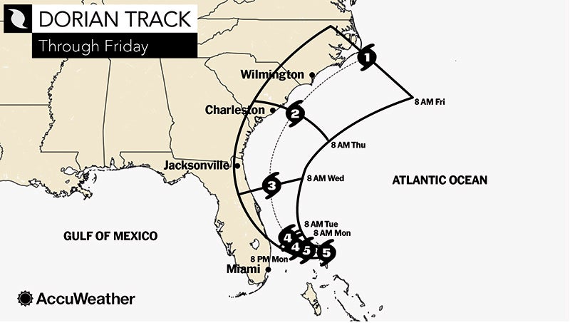
The National Weather Service in Newport/Morehead City is certain about one thing: Hurricane Dorian, if it sticks to its current forecasted track, will unleash massive amounts of rain on eastern North Carolina.
“We’re pretty confident on rain,” a NWS meteorologist stated during a webinar Monday evening. “We have the highest confidence in the rainfall aspect of it.”
Largely stalled Monday over the Bahamas, the currently category 4 storm will weaken as it moves up the East Coast in the coming days. By the time it arrives off the coast of North Carolina, it’s expected to be a category 1 storm, but its impacts could be wide-ranging, according to the NWS. Rainfall is forecasted to be in the 5 to 10 inch range, though locally some areas might receive up to 15 inches between Wednesday night and Friday.
“This is a little track-dependent. We can have rainfall that can go well inland from the coast,” according to NWS.
NWS is urging those in the impact zone to pay less attention to the category of the storm, and more to its possible impacts as the days progress. Until Dorian turns north, the NWS cannot forecast other impacts, such as tropical storm or hurricane force winds, tornados or storm surge, with accuracy.
“Like many of you, this has proven to be a difficult day of ‘sit and wait’ as we continue to search for answers to the many unknowns surrounding Dorian. However, we must not remain idle. We should continue to use this time to our advantage. We encourage everyone to continue your preparation efforts and help your family, friends and neighbors do the same. Your efforts will undoubtedly make Beaufort County and Eastern NC more resilient to whatever Dorian brings our way,” Chris Newkirk, chief of operations of Beaufort County Emergency Services fire/emergency management, wrote in an 9 p.m. update.
Newkirk had more to add to local impacts: “Currently Beaufort County falls along the transition line for rain fall estimations. Areas west of Blounts Creek and Bath are expected to receive 4 to 6 inches of rain, beginning Wednesday night and continuing through Friday. Areas east could see five to 10 inches of rain during the same time period. The communities of Aurora, Pamlico Beach, and Belhaven could see isolated areas with 15 inches. However, these estimations are currently based on a track along or just off shore, and are track dependent.”
More North Carolina


-
Polls
 Loading ...
-
-