National Weather Service issues Hurricane Watch for Beaufort County
Published 11:13 am Tuesday, September 3, 2019
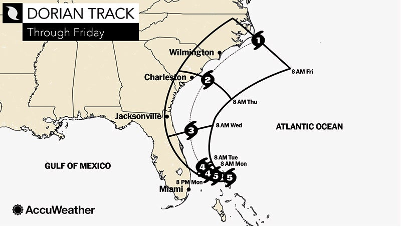
At 11:02 a.m., the National Weather Service issues a Hurricane Watch for Beaufort County.
A Hurricane Watch means hurricane-force winds are possible somewhere within this area within the next 48 hours
* LOCATIONS AFFECTED
– Washington
– Belhaven
– Aurora
* WIND
– LATEST LOCAL FORECAST: Equivalent Strong Tropical Storm force wind
– Peak Wind Forecast: 45-60 mph with gusts to 75 mph
– Window for Tropical Storm force winds: Thursday afternoon until Friday afternoon
– POTENTIAL THREAT TO LIFE AND PROPERTY: Potential for wind 58 to 73 mph
– PLAN: Plan for dangerous wind of equivalent strong tropical storm force due to possible forecast changes in track, size, or intensity.
– PREPARE: Efforts to protect life and property should now be underway. Prepare for significant wind damage.
– ACT: Act now to complete preparations before the wind becomes hazardous.
– POTENTIAL IMPACTS: Significant
– Some damage to roofing and siding materials, along with damage to porches, awnings, carports, and sheds. A few buildings experiencing window, door, and garage door failures. Mobile homes damaged, especially if unanchored. Unsecured lightweight objects become dangerous projectiles.
– Several large trees snapped or uprooted, but with greater numbers in places where trees are shallow rooted. Several fences and roadway signs blown over.
– Some roads impassable from large debris, and more within urban or heavily wooded places. A few bridges, causeways, and access routes impassable.
– Scattered power and communications outages, but more prevalent in areas with above ground lines.
* STORM SURGE
– No storm surge inundation forecast
– POTENTIAL THREAT TO LIFE AND PROPERTY: Little to no storm surge flooding
– PLAN: There is little to no threat of storm surge flooding. Rough surf, coastal erosion, and life-threatening rip currents are possible.
– PREPARE: Little to no preparations for storm surge flooding are needed.
– ACT: Follow the instructions of local officials. Monitor forecasts.
– POTENTIAL IMPACTS: Little to none
– Little to no potential impacts from storm surge flooding.
* FLOODING RAIN
– LATEST LOCAL FORECAST:
– Peak Rainfall Amounts: Additional 4-8 inches, with locally higher amounts
– POTENTIAL THREAT TO LIFE AND PROPERTY: Potential for major flooding rain
– PLAN: Emergency plans should include the potential for major flooding from heavy rain. Evacuations and rescues are likely.
– PREPARE: Strongly consider protective actions, especially if you are in an area vulnerable to flooding.
– ACT: Heed any flood watches and warnings. Failure to take action will likely result in serious injury or loss of life.
– POTENTIAL IMPACTS: Extensive
– Major rainfall flooding may prompt many evacuations and rescues.
– Rivers and tributaries may rapidly overflow their banks in places. Small streams, creeks, canals, and ditches may become dangerous rivers. Flood control systems and barriers may become stressed.
– Flood waters can enter many structures within multiple communities, some structures becoming uninhabitable or washed away. Many places where flood waters may cover escape routes. Streets and parking lots become rivers of moving water with underpasses submerged. Driving conditions become dangerous. Many road and bridge closures with some weakened or washed out.
* TORNADO
– LATEST LOCAL FORECAST:
– Situation is unfavorable for tornadoes
– POTENTIAL THREAT TO LIFE AND PROPERTY: Tornadoes not expected
– PLAN: Tornadoes are not expected. Showers and thunderstorms with gusty winds may still occur.
– PREPARE: Little to no preparations needed to protect against tornadoes at this time. Keep informed of the latest tornado situation.
– ACT: Listen for changes in the forecast.
– POTENTIAL IMPACTS: Little to None
– Little to no potential impacts from tornadoes.
More News


-
Polls
 Loading ...
-
-