Dorian to arrive Thursday with wind, rain and surge
Published 10:07 pm Wednesday, September 4, 2019
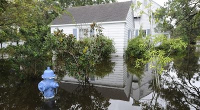
Torrential rainfall, hurricane-force winds, storm surge and the potential for a tornado are Hurricane Dorian’s expected impacts across Beaufort County.
“Our language has changed from ‘possible’ to ‘likely’ to ‘expected,’” said David Glenn, meteorologist-in-charge for the National Weather Service Newport/Morehead City office, during a webinar Wednesday night.
The track for Dorian has largely remained the same, though wind speeds and rainfall amounts have increased since the NWS issued a hurricane warning for Beaufort County late Wednesday morning.
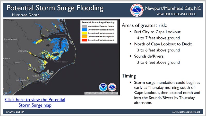
Impacts from Dorian could be felt as early as Thursday morning with wind picking up; by the afternoon, rivers and creeks will begin to rise, according to Glenn.
Western Beaufort County can expect eight to 10 inches of rain; eastern Beaufort County, 10 to 15 inches. Belhaven, Aurora and areas east fall into the “high wind threat” category: Belhaven is projected to have sustained winds of 59 mph; Aurora, 60 mph. Wind and rain are expected to continue from Thursday afternoon through Thursday night, into Friday morning.
Projected storm surge — three to six feet— may seem relatively low in comparison to past storms, but officials warned that all storm surge is life-threatening.
“Winds are going to be picking up late tonight, early tomorrow,” meteorologist Casey Dail asid Wednesday afternoon. “You could begin to see elevated water levels starting tomorrow (Thursday) afternoon. The surge is going to be ahead of the storm. … Water levels start rising tomorrow (Thursday), peaking Thursday night and early Friday. A lot of it could happen after dark, so that could be of concern for folks.”
What could increase storm surge is Dorian slowing down or stalling over the area, as both hurricanes Irene (2011) and Florence (2018) did, but Dail said forecasters are confident that won’t be the case.
“I don’t think that’s going to happen. Everything’s been pretty consistent that it will be moving quickly, and that it won’t stall,” Dail said. “It’ll be moving fairly quickly, as opposed to the last few storms that have impacted the area.”
Local meteorologists are confident in all their forecasts.
“I think what we have right now is pretty accurate for what we can expect for the area,” Glenn said.
HURRICANE DORIAN POTENTIAL IMPACTS
SURGE
Protect against life-threatening surge having possible extensive impacts across coastal eastern North Carolina. Potential impacts in this area include:
- Areas of inundation with storm surge flooding accentuated by battering waves.
- Roads washed out or severely flooded.
- Damage to marinas, docks, boardwalks, and piers. Small craft broken away from moorings, especially in unprotected anchorages with some lifted onshore and stranded.
FLOODING RAIN
Protect against life-threatening rainfall flooding having possible extensive impacts across eastern North Carolina. Potential impacts include:
- Major rainfall flooding may prompt evacuations and rescues.
- Rivers and tributaries may rapidly overflow their banks in multiple places. Small streams, creeks, canals and ditches may become dangerous rivers.
- Flood waters can enter many structures within multiple communities. Flood waters may cover escape routes. Streets and parking lots become rivers of moving water. Driving conditions become dangerous.
- Road and bridge closures with some weakened or washed out.
WIND
Protect against life-threatening wind having possible extensive impacts across coastal eastern North Carolina. Potential impacts in this area include:
- Considerable roof damage to sturdy buildings, with some having window, door and garage door failures leading to structural damage. Mobile homes severely damaged, with some destroyed.
- Damage accentuated by airborne projectiles. Locations may be uninhabitable for weeks.
- Many large trees snapped or uprooted along with fences and roadway signs blown over.
- Some roads impassable from large debris, and more within urban or heavily wooded places. Several bridges, causeways and access routes impassable.
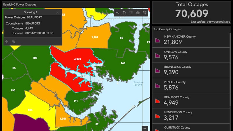
- Areas with power and communications outages.
More Hurricane Stories


-
Polls
 Loading ...
-
-