Dorian to make landfall at Cape Lookout, increased wind, rain threats to Beaufort County
Published 8:47 am Thursday, September 5, 2019
- (National Weather Service)
The 8 a.m. update by the National Weather Service, Newport/Morehead City office calls for increased wind and rain threats for Beaufort County and a slight change in track that has Dorian’s eye making landfall at Cape Lookout and continuing over the southern Outer Banks.
While outer rain bands have already come ashore near Wilmington and Jacksonville, in Beaufort County, weather should start to deteriorate by early afternoon. By 8 p.m. Thursday, residents can expect heavy rain and hurricane-force winds that will increase through the night, into early Friday morning.
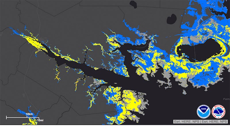
The increase in rainfall amounts looks like 10 to 15 inches throughout the county. Belhaven, Aurora and areas east fall into the “high wind threat” category: Belhaven is projected to have sustained winds of 64 mph; Aurora, 69 mph, with gusts as high as 84 mph in Aurora and 82 in Belhaven. Along the Outer Banks, wind gusts could be as high as 120-plus mph.
Projected storm surge has gone up by a foot in local waterways, from three to six feet above ground to four to seven feet. Rivers will began to rise ahead of the storm, peaking as the eye draws parallel, then will recede, but continue to stay above normal levels due to runoff from torrential rain.
Erik Heden, with NWS, Newport/Morehead City, said eastern North Carolinians can expect to experience Dorian impacts for 18 hours.
All information comes from the NWS Newport/Morehead City 8 a.m. webinar. Stay current with updates throughout the day into Friday.
HURRICANE DORIAN POTENTIAL IMPACTS
SURGE
Protect against life-threatening surge having possible extensive impacts across coastal eastern North Carolina. Potential impacts in this area include:
- Areas of inundation with storm surge flooding accentuated by battering waves.
- Roads washed out or severely flooded.
- Damage to marinas, docks, boardwalks, and piers. Small craft broken away from moorings, especially in unprotected anchorages with some lifted onshore and stranded.
FLOODING RAIN
Protect against life-threatening rainfall flooding having possible extensive impacts across eastern North Carolina. Potential impacts include:
- Major rainfall flooding may prompt evacuations and rescues.
- Rivers and tributaries may rapidly overflow their banks in multiple places. Small streams, creeks, canals and ditches may become dangerous rivers.
- Flood waters can enter many structures within multiple communities. Flood waters may cover escape routes. Streets and parking lots become rivers of moving water. Driving conditions become dangerous.
- Road and bridge closures with some weakened or washed out.
WIND
Protect against life-threatening wind having possible extensive impacts across coastal eastern North Carolina. Potential impacts in this area include:
- Considerable roof damage to sturdy buildings, with some having window, door and garage door failures leading to structural damage. Mobile homes severely damaged, with some destroyed.
- Damage accentuated by airborne projectiles. Locations may be uninhabitable for weeks.
- Many large trees snapped or uprooted along with fences and roadway signs blown over.
- Some roads impassable from large debris, and more within urban or heavily wooded places. Several bridges, causeways and access routes impassable.
- Areas with power and communications outages.
More Hurricane Stories


-
Polls
 Loading ...
-
-