NWS forecasts local Isaias impacts
Published 11:49 am Sunday, August 2, 2020
- (National Weather Service)
|
Getting your Trinity Audio player ready...
|
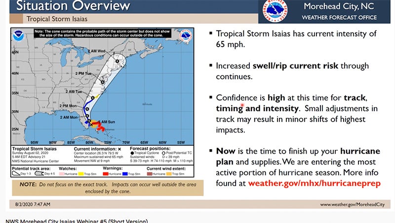
A tropical storm watch has been issued for Beaufort County, as Tropical Storm Isaias makes its way up the East Coast.
According to the latest update from the National Weather Service Newport/Morehead City, tropical storm force winds will likely arrive Monday night.
“The thing that has changed over the last 12 hours is we’re more confident of the timing and intensity,” said Erik Heden, warning coordination meteorologist with NWS Newport/Morehead City.
Storm surge is currently forecasted to be minor — 1 to 2 feet above normally dry areas near the water.
“As far as river flooding goes, we don’t anticipate major issues. Most of our rivers can handle that water,” Heden said.
One to 1 1/2 inches of rain is expected in Belhaven and Aurora, and slightly more for areas west of there.
Maximum sustained winds will be in mid-40s range with gusts of up to 60 mph.
“With that southeast wind, we could see some slight local effects, places like New Bern and Washington, in terms of wind speed,” Heden said.
The greatest threats for eastern North Carolina are rip currents at the coast and the chance of tornadoes, as Isaias is tracking west of the area.
“With that track that would place us on the favorable side for tornadoes,” Heden said. “These will occur well away and ahead of the actual storm’s center and could coincide with folks sleeping, so please have multiple ways to receive those warning.”
Heden encouraged residents to tune into NOAA radio as the storm arrives.
Click HERE to view the PDF version of the NWS update. Click HERE to watch the NWS video presentation.
More Beaufort County


-
Polls
 Loading ...
-
-