Severe weather possible for Thursday
Published 11:05 am Wednesday, March 17, 2021
- Photo submitted by the National Weather Service
|
Getting your Trinity Audio player ready...
|
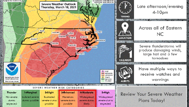
The potential for a regional severe weather outbreak is increasing across the southeastern U.S. tomorrow afternoon and evening, including eastern NC. The Storm Prediction Center has increased our risk level to Moderate for most of the area. This puts part of our area at a threat level of four out of five for Thursday. Click Here for the Wednesday afternoon briefing from the National Weather Service. The main risks remain damaging wind gusts, large hail in excess of 1 inch in diameter, and tornadoes. A few tornadoes could be strong. These risks can lead to downed trees and power lines, as well as isolated or enhanced structural damage to property, infrastructure and crops.
In addition to severe weather, a strong cold front is forecast to push across the region on Friday bringing strong northerly winds. This could lead to minor to moderate coastal flooding for portions of soundside Outer Banks and tidal tributaries, and ocean overwash across the Northern Outer Banks.
Click Here for the latest local update from the National Weather Service.
For more information about the storm and ways to prepare, the National Weather Service office in Morehead City will host a Facebook Live at 7:00 p.m. Click Here to visit the office’s Facebook page and view the livestream.
More News


-
Polls
 Loading ...
-
-