Severe weather outbreak remains likely
Published 9:34 am Thursday, March 18, 2021
|
Getting your Trinity Audio player ready...
|
The National Weather Service continues to monitor severe weather expected to reach eastern North Carolina as soon as this afternoon.
Read the latest briefing HERE.
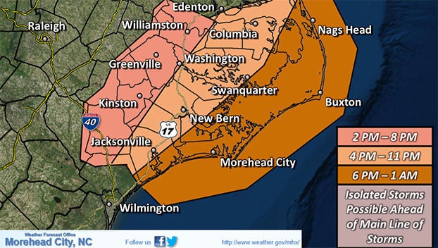
The Moderate Severe Outlook has been trimmed back to areas south of Highway 70, but we are still expecting severe weather late this afternoon into this evening across all of Eastern NC. In addition, strong winds developing behind a cold front Friday should result in potential coastal flooding Friday and into the weekend.
The potential for a regional severe weather outbreak remains likely across the southeastern U.S. this afternoon and evening, including eastern NC. The Storm Prediction Center continues a Moderate Risk (4/5) for a portion of the area. All severe hazards remain possible including damaging wind gusts, large hail in excess of 1 inch in diameter, and tornadoes. A few tornadoes could be strong, especially in the Moderate Outlook area.
Additionally, a strong cold front is forecast to push across the region on Friday bringing strong northerly winds. This could lead to minor to moderate coastal flooding for portions of soundside Outer Banks and tidal tributaries, and ocean overwash across the Northern Outer Banks.
Gale Warnings, Wind Advisories, and Coastal Flood Watches have been issued in anticipation of the strong winds Friday into the weekend.
The next briefing is planned for this afternoon before 5 p.m. For more information visit the National Weather Service.
More News


-
Polls
 Loading ...
-
-