Potential for severe weather Thursday-Friday
Published 8:58 am Thursday, October 28, 2021
|
Getting your Trinity Audio player ready...
|
From Chris Newkirk
Beaufort County Emergency Services
Our office continues to monitor the potential for severe weather later today. Current forecast details for Beaufort County are as follows:
Rain
Rain chances will begin to increase around 7pm this evening, and continue through 6pm Friday. The greatest chance of rain will be between 10p and 6am, with most areas receiving ½” during this time. (Please note, higher localized amounts of rain are possible depending on the tracks of storm cells.)
Winds
Winds will transition to the East around noon today and become sustained between 8 and 15mph through sunset Friday. Gust of 15 – 20mph will be possible during this time.
Severe Thunderstorms
Severe thunderstorms capable of producing damaging wind gust, a few tornados and locally heavy rains are possible anytime between 6pm this evening and sunrise tomorrow morning.
*Please see the email below and attached briefings from the National Weather Service for more information.*
Please take a moment today to ensure that you, your family, friends and neighbors have a way of being notified of any watches / warning that may be issued during the overnight hours. (ie. weather radios, push notifications from weather service and local media apps, etc.) We also encourage everyone to continue to monitor local media outlets for forecast updates.
As always, thank you all for what you do to keep Beaufort County informed, prepared and safe.
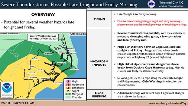
From NWS Morehead City
Here’s an update on the weather situation for late tonight into Friday.
Severe thunderstorms are possible late tonight into Friday morning. Damaging wind gusts, a few tornadoes, and locally heavy rainfall are possible. There is a chance that stronger storms and the associated severe threat will remain offshore. Regardless, we strongly encourage you to have multiple ways to receive warnings.
A High Surf Advisory has been issued for the beaches from Duck to Cape Lookout, where rough surf, minor beach erosion are expected and localized ocean overwash is possible along portions of Highway 12.
High rip current risk with dangerous shorebreak from Duck to Cape Hatteras today.
Please see the attached briefing for details.

More Weather

-
Polls
 Loading ...
-
-