Update on Tropical Storm Ian
Published 10:13 pm Sunday, September 25, 2022
|
Getting your Trinity Audio player ready...
|
From Chris Newkirk, Beaufort County Emergency Services
Tropical Storm Ian update
The latest forecast update continues to trend towards a more northern track, with the center of Ian making landfall along the Florida panhandle, and moving north across central Georgia, and western South and North Carolina. Generally speaking, this latest update and track is currently forecasted to bring the following conditions to our area between late Thursday night and Monday morning.
Rain
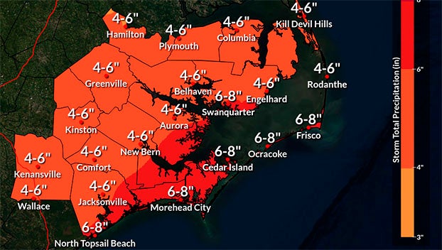
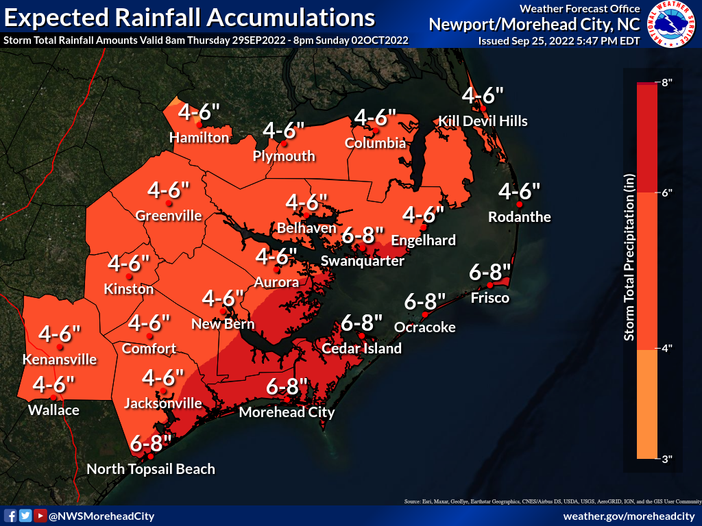
- 4 to 6 inches of rain, with heavy downpours capable of causing localized flash flooding is possible.
- Our greatest chance of rain is currently forecasted to occur Friday afternoon / night.
Winds
- Winds are currently forecasted to be sustained between 15 and 20 mph Thursday through Monday, with gust of 25 – 35 mph possible Thursday and Friday.
While forecast models are becoming more in agreement, this outlook remains very track dependent, and could change as we go through the week.
Please see below and attached briefing from the NWS for more information:
No significant changes to the Tropical Storm Ian forecast with the 5pm NHC update: Tropical Storm Ian is still forecast to strengthen into a major hurricane while moving into the southeastern Gulf of Mexico mid-week.
Impacts are possible across Eastern NC late week and early next weekend, but will be highly dependent on the track. While forecast confidence is increasing, and will continue to increase every day, the track is likely to change over the next few days.
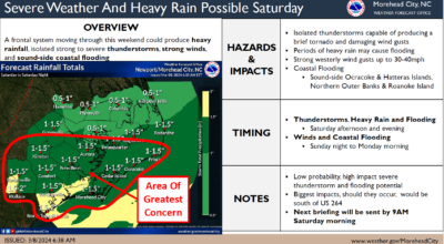
At this time, the most probable impacts from this system will be periods of widespread heavy rain and coastal flooding impacts late next week and next weekend. It is still too early to give specific details regarding severity and timing of the coastal flooding impacts, but we will be sure to update you as forecast confidence and probabilities increase. Please see the attached briefing and the rainfall accumulation graphic at the bottom of this post.
We will monitor the progress and evolution of this system and will provide additional briefings as the forecast warrants.
Please see the attached briefing for additional details. Remember, you can monitor conditions in the tropics at https://www.weather.gov/mhx/tropical.
NWS Morehead City TC Ian Briefing #4 Sep 25th 2022.pptx
More Weather

-
Polls
 Loading ...
-
-