Hurricane Ian: Sept. 26 PM update
Published 7:26 pm Monday, September 26, 2022
|
Getting your Trinity Audio player ready...
|
From Chris Newkirk, Beaufort County Emergency Services
Please see below and attached briefing for the latest update from the NWS. Minor changes continue to be made to the rainfall forecast for Beaufort County. These changes have been highlighted below.
Rain
- 3 to 4 inches of rain is forecasted for our area. Our greatest chance of rain and highest hourly accumulation is currently forecasted to occur between 8pm Friday night and noon Saturday. Heavy downpours capable of causing localized flash flooding is possible during this time.
Winds
- Winds are currently forecasted to be sustained between 15 and 20 mph Thursday through Monday, with gust of 25 – 35 mph possible Thursday through Saturday.
As previously mentioned, this outlook remains very track dependent, and will most likely continue to change over the next several days.
We will continue to pass along information as we receive it.
From the NWS Newport/Morehead City:
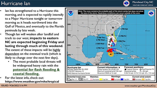
Hurricane Ian continues to strengthen and is expected to intensify to a Major Hurricane tonight or early tomorrow morning before approaching the Dry Tortugas and Florida Keys.
Not much has changed regarding the official track forecast, though confidence is increasing that Eastern NC will feel impacts from this system, with the greatest threats continuing to be heavy rainfall and the potential for flash flooding, as well as coastal flooding.
With subtle changes in forecast track and intensity for days 1-3 leading to much larger deviations in the 4-5 day forecasts, it is still too early to get into specifics. We are still at least one to two days away from being able to give more detailed forecasts regarding severity and timing of the coastal flooding impacts, but we will continue to update as forecast confidence and probabilities increase.
Rainfall totals, which are also likely to fluctuate with track forecast changes, continue to show increasing probabilities of extended periods of heavy rainfall. We continue to expect the heaviest rainfall along the coast. However, please be aware that the rainfall forecast is highly dependent on the eventual track and speed of Ian through the Southeast US, and the area of maximum rainfall may shift.
We will monitor the progress and evolution of this system and will provide additional briefings as the forecast warrants.
Please see the attached briefing for additional details. Remember, you can monitor conditions in the tropics at https://www.weather.gov/mhx/tropical.
NWS Morehead City TC Ian Briefing #6 Sep 26th 2022
More Weather

-
Polls
 Loading ...
-
-