Hurricane Ian: Sept. 30 AM update
Published 8:19 am Friday, September 30, 2022
|
Getting your Trinity Audio player ready...
|
From Chris Newkirk, Beaufort County Emergency Services:
Please see the email below and attached briefing for the latest update from the NWS.
Most forecast models are now suggesting that Ian will make its second landfall between Charleston and Georgetown S.C as a Category 1 hurricane. Changes as a result of this morning’s update have been highlighted below.
Rain
- 4 to 6 inches of rain is forecasted for our area. Our greatest chance of rain and highest hourly accumulation is currently forecasted to occur through 7pm this afternoon. Heavy downpours capable of causing localized flash flooding is possible during this time.
- Weather Stations throughout Beaufort Co. are currently reporting ½ to 1 ¼ inches of rain so far. These weather stations can be viewed utilizing the “Quick Links” tab at the bottom of this webpage. https://co.beaufort.nc.us/245/Emergency-Management)
- Most of the rain should be exiting our area after midnight Friday, with only light rain expected after sunrise Saturday.
Winds
- Winds are currently forecasted to be sustained between 15 and 20 mph through midnight Friday, with frequent gust of 30 – 40 mph possible during this time.
- The highest wind gust reported so far has been 36 mph in Belhaven.
- Our highest winds are forecasted to occur through 2pm today.
Storm Surge
- A Coastal Flood Watch has been issued for Beaufort County. Persistently high NE winds will beginning transitioning to the east around sunset Friday, becoming SE by midnight and S by sunrise. These conditions are expected result in the following:
- 2 to 3 feet of inundation is expected along the coastal areas of the Pamlico River. (Areas near the back of Chocowinity Bay and west of Washington are expected to be on the higher side of this scale.)
- 1 ½ to 3 feet above normal is currently being reported along the Pamlico River. The Washington Waterfront is currently reporting the highest, at 2.7 feet above normal. (River gauges can be viewed at https://fiman.nc.gov/map.aspx?video=false)
- 1 to 3 feet is expected for areas along the Pungo River.
- 2 to 3 feet of inundation is expected along the coastal areas of the Pamlico River. (Areas near the back of Chocowinity Bay and west of Washington are expected to be on the higher side of this scale.)
Note: These values and timelines may change with future updates.
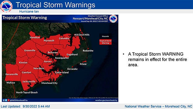
From NWS Newport/Morehead City:
No big changes with this update. The threats of heavy rain, strong winds, coastal flooding, and isolated tornadoes have not changed. The highest impacts for both heavy rain and the tornado threat will occur today. Please encourage people to have multiple ways to receive warnings today, if tornado warnings are issued.
We are already seeing some elevated water levels along the lower Neuse River and the southern part of the Pamlico Sound (Downeast Carteret). This will continue today. Eventually winds will shift to the southeast later today, and new areas will be impacted by elevated water levels. The storm is currently moving north northeast at 9 mph and has started to begin its turn to the north as it approaches the South Carolina coast. Unless needed, this will be the last email briefing on the storm.
Please see the attached briefing for additional details. Remember, you can monitor conditions in the tropics at https://www.weather.gov/mhx/tropical.
NWS Morehead City Hurricane Ian Briefing #14 Sep 30th 2022
More Weather

-
Polls
 Loading ...
-
-