Hurricane Ian: Sept. 30 Noon update
Published 12:50 pm Friday, September 30, 2022

|
Getting your Trinity Audio player ready...
|
From Chris Newkirk, Beaufort County Emergency Services:
Please note the updates below.
Storm Surge
We have been communicating with the National Weather Service regarding the storm surge values along the Pamlico River. We are currently experiencing 3 +/- feet. The NWS is now expecting the Pamlico to peak between 4 ½ and 5’. Water levels are forecasted to continue to rise quickly through the 3 – 6pm timeframe. Those levels are expected to remain through midnight tonight, before very slowly rescinding through sunrise Saturday morning.
This updated surge forecast will most likely result in minor inundation of some of our known low lying roads, especially those along and adjacent to the shoreline areas west of Broad Creek / Chocowinity Bay. Please avoid driving through standing water.
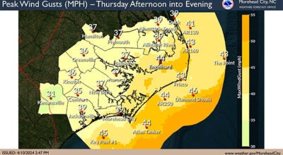
Winds
Our highest winds are expected to occur between now and 10pm tonight, with frequent gust of 35+ mph likely.
Please share pictures of any storm related damage / flooding with us at https://www.facebook.com/bcemergencymanagement/
More Weather

-
Polls
 Loading ...
-
-