Coastal Flooding & TS Nicole: AM Update (11/9/22)
Published 9:56 am Wednesday, November 9, 2022
|
Getting your Trinity Audio player ready...
|
From Chris Newkirk / Beaufort County Emergency Services:
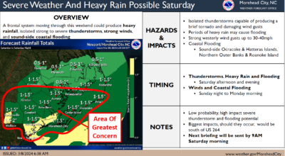
This morning’s update from the National Weather Service has reduced the total rainfall amount for our area, and elevated the severe weather threat for Friday. Details associated with these changes have been highlighted below.
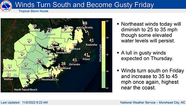
A high pressure system will continue to bring sustained NE winds between 10 and 15 mph throughsunrise tomorrow (Thursday). Frequent gust between 20 and 30 mph are likely through 7pm tonight. These conditions are expected to keep our waterways 1 to 2 feet above normal.
Remnants of Tropical System Nicole is expected to move through North Carolina Thursday night / Friday, impacting Beaufort County as follows.
Rain
- Rain chances begin to increase after 1am Friday morning and continue through midnight, with ½ to 1 inch currently forecasted for our area.
- Our greatest chance of rain is currently forecasted to occur between 7am and 7pm Friday,with our heaviest rains expected between 7am and 1pm.
Winds
- Sustained winds between 10 and 20 mph are expected from 7pm Thursday through sunrise Saturday morning. Frequent gust between 20 and 30 mph are likely between 7am and midnight Friday.
- Our highest winds are forecasted to occur between 1pm and 10pm Friday.
- These winds will transition as follows:
- East winds between 8am Thursday and 2am Friday.
- SE winds between 2am and 1pm Friday.
- South winds between 1pm Friday and 2am Saturday.
- SW winds between 2am and 6am Saturday.
- West winds between 6am and 8pm Saturday.
These transitioning winds will result in brief periods in which water is pushed in to and pulled out of susceptible waterways throughout our county.
Severe Thunderstorms / Tornados
- Strong to severe thunderstorms, as well as isolated tornados are possible during the daylight hours Friday, with our greatest threat occurring between 1pm and 7pm as bands associated with Nicole move through our area.
Please see the below and attached briefing from the National Weather Service for additional information:
From the National Weather Service - Newport/Morehead City:
The latest changes with this briefing are to lower expected rainfall amounts, but increase the severe threat, mainly in the form of isolated tornadoes for Friday.
See attached for details on the expected impacts from this long duration event.
NWS Morehead City Coastal Flooding & TC Nicole Briefing #5
More Weather

-
Polls
 Loading ...
-
-