Tropical Storm Nicole: AM Update (11/10/22)
Published 9:53 am Thursday, November 10, 2022
- (National Weather Service, Newport/Morehead City)
|
Getting your Trinity Audio player ready...
|
From Chris Newkirk / Beaufort County Emergency Services:
This morning’s update from the National Weather Service has made minor changes to the timing of the forecasted impacts to Beaufort County. These changes have been highlighted below.
Remnants of Tropical System Nicole is expected to move through North Carolina Thursday night and Friday, impacting Beaufort County as follows.
Rain
- Rain chances begin to increase after 1am Friday morning and continue through midnight, with ½ to 1 inch currently forecasted for our area.
- Our greatest chance of rain is currently forecasted to occur between 1am and 7pm Friday, with our heaviest rains expected between 6am and 1pm.
Winds
- Sustained winds between 10 and 15 mph are expected from 2am Friday through 2am Saturday morning. Frequent gust between 20 and 25 mph are likely between 11am and midnight Friday.
- Our highest winds are forecasted to occur between 2pm and midnight Friday.
- These winds will transition as follows:
- East winds between 4pm Thursday and 8am Friday.
- SE winds between 8am and 7pm Friday.
- South winds between 7pm Friday and 2am Saturday.
- SW winds between 2am Saturday and 2am Sunday.
- West / NW winds after 2am Sunday.
These transitioning winds will result in brief periods in which water is pushed in to and pulled out of susceptible waterways throughout our county.
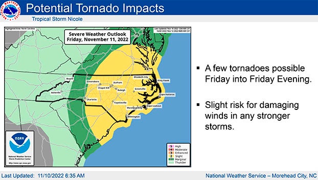
Severe Thunderstorms / Tornados
- Strong to severe thunderstorms, as well as isolated tornados are possible between 7am and midnight Friday, as bands associated with Nicole move through our area.
Please see below and attached briefing from the National Weather Service for additional information.
We encourage everyone to ensure that you, your family, friends and neighbors have a way of receiving weather related watches and / or warnings. (Alert notifications on your cell phone and other smart devices, weather radios, etc.)
From National Weather Service, Newport/Morehead City:
Minor coastal flooding has abated as the gusty northeast winds have diminished, therefore remaining coastal flood advisories in effect today will expire after this morning’s high tide, which is around 8:30 AM.
We want to turn your attention to Friday, when the impacts from the remnants of TC Nicole are expected across Eastern NC. The main impact from Nicole will be the threat for a few tornadoes and severe wind gusts in thunderstorms, as outer bands from the storm move through the area. The tornado threat is expected to begin by around sunrise, and last through much of the morning into early afternoon. There may be a break in showers and storms later in the afternoon, though another round of showers and storms, again with a tornado and damaging wind risk, could impact Eastern NC in the evening. Any severe threat should be over by around midnight.
As south winds increase late in the day Friday and peak Friday night, some minor water level rises are possible on the Soundside of Hatteras Island north of Buxton. Winds turn southwest late Friday night into early Saturday, with the potential for minor inundation continuing Saturday morning, with improving conditions by the afternoon.
See attached 2-page briefing for the tornado and coastal flood threat details.
NWS Morehead City Coastal Flooding & TC Nicole 2-Slider 11-10-22 7AM
More Weather

-
Polls
 Loading ...
-
-