Tropical Depression Nicole: AM Update (11/11/22)
Published 9:26 am Friday, November 11, 2022
|
Getting your Trinity Audio player ready...
|
From Chris Newkirk / Beaufort County Emergency Services:
This morning’s update from the National Weather Service included a Tornado Watch for Beaufort County, and made minor changes to the forecasted impacts for our area. These changes have been highlighted below.
Rain
- Rain chances will continue through 4am Saturday, with most areas expected to receive another ¼ to ½ inch of rain as bands continue to move through Eastern NC.
- Our greatest chance of rain is currently forecasted to occur between 10am and 3pm today, with our heaviest rains expected between noon and 2pm.
Winds
- Sustained winds between 10 and 15 mph are expected through 4am Saturday morning, with frequent gust of 25 to 35 mph likely during this time.
- Our highest winds are forecasted to occur between 1pm today and 2am Saturday.
- These winds will transition as follows:
- SE winds between 8am and 7pm Friday.
- South winds between 7pm Friday and 4am Saturday.
- SW winds between 4am Saturday and 2am Sunday.
- West / NW winds after 2am Sunday.
These transitioning winds will result in brief periods in which water is pushed in to and pulled out of susceptible waterways throughout our county.
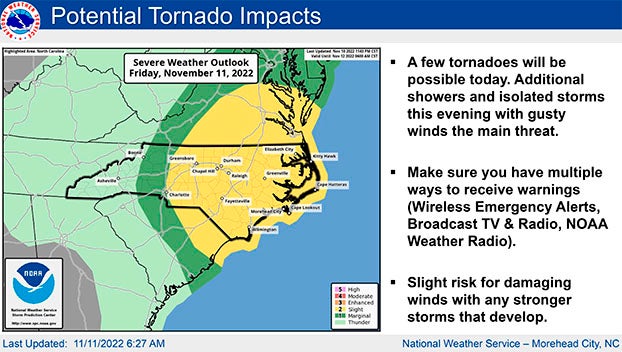
Severe Thunderstorms / Tornados
- Strong to severe thunderstorms, as well as isolated tornados are possible through 7pm today.
- A Tornado Watch has been issued for Beaufort County until 3pm.
Please see below and attached briefing from the National Weather Service for additional information.
We encourage everyone to ensure that you, your family, friends and neighbors have a way of receiving weather related watch and / or warning notifications. (Alert notifications on your cell phone and other smart devices, weather radios, etc.)
From National Weather Service, Newport/Morehead City, NC:
**Tornado Watch in Effect for all of Eastern NC through 3 PM**
Nicole has weakened further to a Tropical Depression as the center of circulation moves northeastward through Georgia. Impacts from the remnant storm are still expected however. The main threat will be the possibility for a few tornadoes today, and a Tornado Watch is in effect for all of Eastern NC through 3PM this afternoon. There may be a break in the showers and storms by late afternoon through early evening, but additional showers with some embedded thunder are possible later this evening before it all moves off the coast late tonight. Activity this evening is not expected to be severe, though some periods of gusty winds in heavier showers are still possible.
As south winds increase late in the day today, and peak tonight, minor water level rises are possible on the soundside of Hatteras Island north of Buxton to Duck, as well as for Mainland Dare County. A Coastal Flood Advisory remains in effect for these locations from tonight through Saturday afternoon.
See the attached 2-page briefing for details on the tornado and coastal flood threat.
NWS Morehead City Coastal Flooding & Tornadoes 2-Slider 11-11-22 7AM
More Weather

-
Polls
 Loading ...
-
-