Developing weather pattern through Dec. 29
Published 2:03 pm Wednesday, December 21, 2022
|
Getting your Trinity Audio player ready...
|
From Chris Newkirk, Beaufort County Emergency Services:
This morning’s update from the National Weather Service lowered the forecasted temperatures for Beaufort County as we go through the weekend. Those changes have been highlighted below.
Thursday
- Rain chances begin to increase after 1am, with rain likely by sunrise. Rain will continue through midnight Thursday, with most areas receiving 1 to 1 1/2″inchs. Our heaviest rains are expected between 1pm and 6pm.
- Strong to severe thunderstorms are possible between 11am and 5pm.
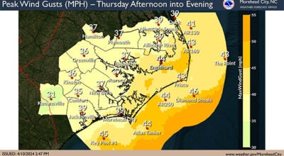
- SE winds will begin to increase after sunrise, becoming sustained between 10 and 15 mph around noon. Gust of 25 to 30 mph are likely between 10am and 7pm. These winds will begin transitioning from the SE to the SW around sunset.
Friday
- SW winds will become sustained between 20 and 25 mph by 10am, and continue through sunset. Gust of 40 to 45 mph are likely during this time. Winds will transition from the SW to the W after sunset and remain sustained between 15 and 20 mph overnight, with frequent gust of 20 to 30 mph likely.
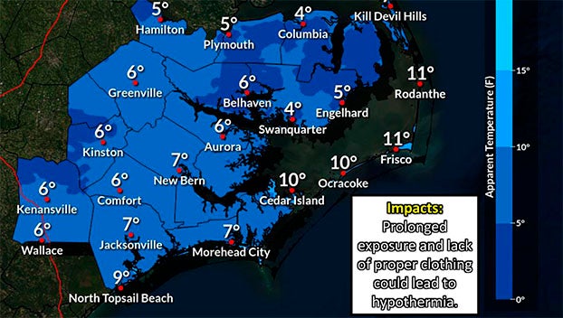
- We are expected to reach our high temperature of 55 degrees at 10am Friday morning, with temperatures dropping during the remainder of the day. We are forecasted to be around 30 degrees by sunset, with a windchill of 19. Our overnight low is expected to occur around 7am Saturday morning with a temperature of 16 and a windchill of 4 degrees.
Saturday (Christmas Eve)
- W winds will remain sustained between 10 and 15 mph through sunset, with gust of 20 to 25 mph likely.
- We are expected to reach a high temperature of 30 degrees around 1pm, with a windchill of 19. Our overnight low is forecasted to occur around 6am Christmas morning, with a temperature of 16 degrees and a windchill of 9.
Sunday (Christmas Day)
- W winds will remain sustained between 5 and 10 mph. Winds will begin to transition from the W to the SW around 8pm.
- We are expected to reach a high temperature of 36 degrees around 1pm, with a windchill of 30. Our overnight low is forecasted to occur around 4am Monday morning, with a temperature of 19 degrees.
Monday
- Winds will transition to the S and be sustained around 5 mph.
- A high of 40 degrees is expected around 1pm, with an overnight low of 24.
Tuesday & Wednesday
- Winds will transition to the N on Tuesday and remain sustained around 5mph through Wednesday.
- Highs of 47 to 50 degrees and overnight lows of 28 to 30 degrees are expected for both days.
See the attached briefing and email below for the National Weather Service for their latest update.
Please take time today to ensure that any outside pets and / or livestock have adequate shelter to protect them from these forecasted impacts. We also encourage everyone to ensure that any exposed plumbing is protected from freezing temperatures.
From National Weather Service, Newport/Morehead City:
Attached is an updated overview of the potential weather impacts later this week and into this weekend associated with the strong weather system that will be moving through the region.
WHAT HAS CHANGED: Confidence is increasing regarding the potential for strong winds, cold temperatures, heavy rain, dangerous marine conditions, and coastal hazards with impacts beginning Thursday and continuing on into this weekend.
NWS Morehead City Multiple Hazards Briefing #3 December 22-24, 2022
More Weather

-
Polls
 Loading ...
-
-