Potential for severe weather this afternoon
Published 9:56 am Tuesday, May 9, 2023
|
Getting your Trinity Audio player ready...
|
From Chris Newkirk / Beaufort County Emergency Services:
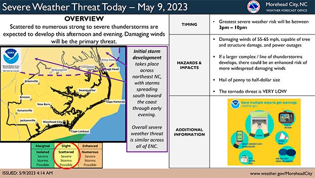
Our office continues to monitoring the potential for severe weather later this afternoon. This morning’s update from the National Weather Service includes an increasing threat of high winds as well as a more precise timeline. Those changes have been highlighted below.
Forecast Details for Beaufort County.
Winds
- West winds will become sustained around 10 mph by noon, with frequent gust between 15 and 20 mph continuing through 5pm Wednesday.
- Passing severe storms could be capable of producing winds gust as high as 55 -65 mph.
Rain
- Rain is possible between 4pm and 10pm, , with less ¼ of an inch expected.
- The greatest chance of rain is currently forecasted to occur between 6pm and 8pm
Severe Weather / Thunderstorms
- Thunderstorms are also possible between 4pm and 10pm, with the greatest chance occurring between6pm and 8pm.
- High winds, frequent lightening and the possibility of hail will be the greatest threat associated with these passing storms.
Please see the email below and attached briefing from the National Weather Service (NWS) for more information.
We encourage everyone to continue to monitor local media outlets for additional updates, as well as any watches and / or warnings that may be issued.
—
From the National Weather Service:
The potential for severe weather is still on the table for all of Eastern North Carolina later today through this evening.
The primary risk continues to be damaging wind gusts as high as 55-65 mph and frequent lightning. Winds of this magnitude will be capable of more than just tree damage. The tornado risk is very low.
The main window for severe weather is from 3pm – 10pm, developing from north to south.
Please see the attached one-pager for additional information:
NWS Morehead City – Severe Weather Threat Tuesday – Briefing #2
More Weather

-
Polls
 Loading ...
-
-