Hurricane Florence update: Sept. 10, 11 a.m.
Published 11:13 am Monday, September 10, 2018
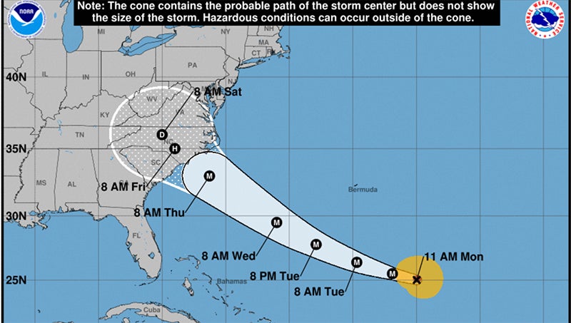
Hurricane Florence has intensified to a Category 2 hurricane and is expected to make landfall near Wilmington as a Category 4 hurricane on Thursday evening.
The National Weather Service is predicting 6 to 12 inches of rain for the area. Flooding is likely, both flash flooding initially, followed by longterm river flooding. Tropical storm force winds are expected to be felt in the region as early as Wednesday night.
From the National Hurricane Center:
1. A life-threatening storm surge is likely along portions of the coastlines of South Carolina, North Carolina, and Virginia, and a Storm Surge Watch will likely be issued for some of these areas by Tuesday morning. All interests from South Carolina into the mid-Atlantic region should ensure they have their hurricane plan in place and follow any advice given by local officials.
2. Life-threatening freshwater flooding is likely from a prolonged and exceptionally heavy rainfall event, which may extend inland over the Carolinas and Mid Atlantic for hundreds of miles as Florence is expected to slow down as it approaches the coast and moves inland.
3. Damaging hurricane-force winds are likely along portions of the coasts of South Carolina and North Carolina, and a Hurricane Watch will likely be issued by Tuesday morning. Damaging winds could also spread well inland into portions of the Carolinas and Virginia.
4. Large swells affecting Bermuda and portions of the U.S. East Coast will continue this week, resulting in life-threatening surf and rip currents.
Hurricane Florence coverage will continue to be updated throughout the day.
More Hurricane Stories


SportsPlus
How to Watch the MLB Baseball Playoffs on Saturday, Oct. 19: TV Channel, Live Streaming, Start Times
The New York Yankees and the Cleveland Guardians take the field in one of many compelling matchups on…
MLB Playoff Betting Lines and Picks Today | Oct. 19
The MLB Playoff matchups in a Saturday schedule sure to please include the New York Yankees taking on…
Buy Tickets for Carolina Hurricanes vs. St. Louis Blues on October 19
The Carolina Hurricanes and St. Louis Blues square off at Enterprise Center on Saturday, October 19 at 7:00…
Sebastian Aho Player Prop Bets for the Hurricanes vs. Blues Game – October 19
Sebastian Aho will be on the ice Saturday when his Carolina Hurricanes face the St. Louis Blues at…
Martin Necas Player Prop Bets for the Hurricanes vs. Blues Game – October 19
Martin Necas and the Carolina Hurricanes will be in action on Saturday at 7:00 PM ET, facing the…
-
Polls
 Loading ...
-
-