Sheriff’s Office offers map to keep track of hazards
Published 9:40 am Friday, September 14, 2018

- A map of local hazards can help you stay informed on conditions without having to leave the safety of your home.
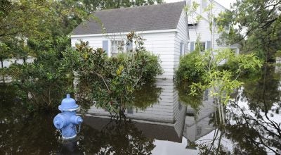
As the wind, rain and storm surge from Hurricane Florence continue to affect the area, more and more roads are becoming impassable due to flooding, trees across roadways and/or downed powerlines. The Beaufort County Sheriff’s Office designed a SARTopo map that shows all reported impassable roadways. The map can be found here. Roads that are flooded will be highlighted in red.
More Hurricane Stories


SportsPlus
Buy Tickets for Carolina Hurricanes vs. Tampa Bay Lightning on October 11
The Carolina Hurricanes host the Tampa Bay Lightning on Friday, October 11 at 7:00 PM ET on ESPN+.…
How to Watch MLB Baseball on Saturday, Sept. 28: TV Channel, Live Streaming, Start Times
The New York Mets versus the Milwaukee Brewers is one of many solid options on today’s MLB slate.…
MLB Betting Lines and Picks Today | Sept. 28
Saturday’s MLB schedule has plenty of quality competition in store. Among those games is the New York Mets…
Best Bets, Odds for the Panthers vs. Bengals Game – Week 4
Check out best bets as the Cincinnati Bengals (0-3) will attempt to stop a three-game losing streak when…
Where to Watch East Carolina vs. UTSA on TV or Streaming Live – Sept. 28
On Saturday at 4:00 p.m. ET, the UTSA Roadrunners (2-2) will take on Jake Garcia and the East…
-
Polls
 Loading ...
-
-