NWS warning of strong rip tides at beach, uncertainty in long-term Dorian forecast
Published 5:55 pm Friday, August 30, 2019
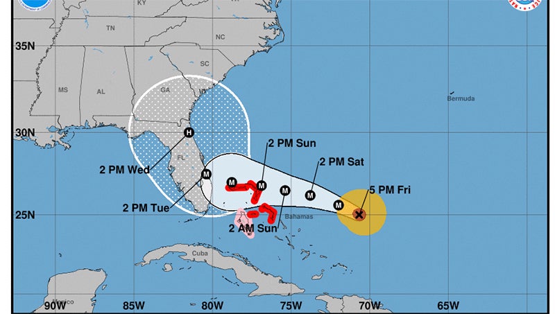
- (National Hurricane Center)
With Hurricane Dorian’s extended path unforeseeable for now, the National Weather Service in Morehead City does have a message for North Carolina beachgoers this weekend: beware of rip currents.
“We will see impacts from Dorian through this weekend and next week, with an enhanced risk of rip currents. Please share this message with the expected increase in beach attendance this Labor Day weekend,” Erik Heden, NWS Newport/Morehead City warning coordination meteorologist, wrote in an email Thursday.
Heden also warned all coastal Carolinians to keep up with the storm’s progress over the next several days.
“The models show a large range of possibilities the middle to end of next week with Dorian, so any impacts on our area are VERY uncertain. Bottom line is you should be paying close attention to this storm and be prepared to monitor the forecast over the holiday weekend,” Heden wrote.
Chris Newkirk, chief of operations for fire/emergency management with Beaufort County Emergency Services, said it will likely be Sunday before his office will know whether there will be local impact from what has become a highly unpredictable storm.
“It is still something that we need to continue to watch. When we last spoke (on Wednesday), there was a just a lot of variables with this storm and that continues to prove evident with this forecast: the storm slowed down, the direction and the location of the turn has changed,” Newkirk said. “The uncertainty of that forecast will continue probably over the next 24 hours, for sure.”
Hurricane Dorian is expected to make landfall in Florida as a category 4 hurricane, however, it is what happens after that that is unclear. According to the National Weather Service, a strong-subtropical ridge will steer Dorian toward the northwestern Bahamas and the Florida peninsula, however, that ridge is expected to erode, leaving an uncertain track. Some models have the storm moving north through Georgia and the Carolinas.
“Tropical Cyclone Dorian is expected to slowly lift north along the southeast coast early next week and eventually turn to the northeast mid to late week. It is much too early to speculate on the exact track and timing, or potential impacts the system may bring to
eastern North Carolina but all interest are urged to monitor updates closely over the next week,” the National Weather Service update read on Friday.
“Like we’ve said all along, it’s a dynamic forecast with all the variables at play and the slightest variances can really have a significant impact,” Newkirk said.
Newkirk said his office will likely send out a Saturday update if there are major developments. The Washington Daily News will post any updates received from Emergency Services over the weekend on www.thewashingtondailynews.com.
More News


SportsPlus
East Carolina vs. Charlotte Oct. 5 Tickets & Start Time
AAC foes will square off when the East Carolina Pirates and Charlotte 49ers meet on Saturday, October 5,…
How to Watch MLB Baseball on Monday, Sept. 30: TV Channel, Live Streaming, Start Times
The MLB lineup today, which includes the New York Mets taking on the Atlanta Braves, should provide some…
AAC Football Power Rankings for Week 6
With Week 6 of the college football schedule fast approaching, which teams are the leading contenders at the…
MLB Betting Lines and Picks Today | Sept. 30
In one of the many exciting matchups on the MLB slate today, the New York Mets and the…
Week 6 College Football Computer Picks & Predictions
According to our projections, the best bet against the spread among Week 6’s 49 FBS matchups is Clemson…
-
Polls
 Loading ...
-
-