National Weather Service urges preparation for Dorian, local impacts uncertain
Published 11:04 am Tuesday, September 3, 2019
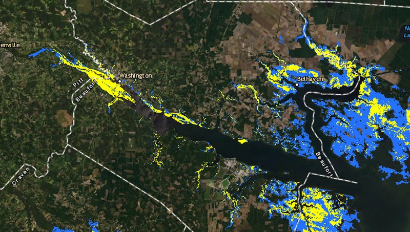
- STORM SURGE ESTIMATES: This map from the National Weather Service shows the potential for storm surge of one to more than three feet along the Pamlico and Pungo rivers, along with their tributaries. Storm surge impact could fluctuate greatly depending on the actual track the hurricane.
The National Weather Service in Newport/Morehead City is advising residents of eastern North Carolina to complete preparations for the arrival of Hurricane Dorian by Wednesday, as the region will see the greatest impacts from the storm from Wednesday evening through Friday.
According to information provided in a 9:30 a.m. NWS briefing on Tuesday, rain is likely arrive in eastern North Carolina Wednesday and continue through Friday, with tropical storm-force winds most likely to arrive Thursday, continuing to Friday. Rainfall totals of 4-10 inches are expected throughout the area.
“The concern here is the rainfall rate, so that could produce some issues with flash flooding,” National Weather Service Warning Coordination Meteorologist Erik Heden said. “We’re very dry, so hopefully that will alleviate major concerns with river flooding.”
While the latest storm surge maps show anywhere from one to more than three feet along the Pamlico and Pungo rivers, the actual totals will be dependent on the track the storm takes. NWS meteorologists say they should have a better idea of specific impacts later today.
The NWS lists the highest threat as rainfall and areal flooding,with a moderate threat for storm surge and wind and a lower threat of tornados.
Although confidence remains high that the storm will impact eastern North Carolina, the NWS says that specific impacts are still difficult to determine at this point, and that the significant changes are still possible based on the track of the storm.
The next NWS briefing will take place at 6:30 p.m.
More Hurricane Stories


SportsPlus
How to Watch the NBA Today, November 9
In one of the four intriguing matchups on the NBA schedule today, the Brooklyn Nets and Cleveland Cavaliers…
November 9 NHL TV Schedule: TV Channel, Start Times & Live Streaming Options
In a Saturday NHL slate that features a lot of exciting contests, the Dallas Stars versus the Winnipeg…
NBA Spread and Total Picks for Today, November 9
The Utah Jazz versus the San Antonio Spurs is one of many solid options on today’s NBA slate.…
Top 25 College Hoops Picks Against the Spread – Saturday, November 9
Top 25 teams will be in action in six games on Saturday’s college basketball schedule. That includes the…
How to Pick the Hurricanes vs. Avalanche Game with Odds, Spread, Betting Line and Stats – November 9
Saturday’s NHL schedule includes a matchup between the Carolina Hurricanes and the Colorado Avalanche at Ball Arena, with…
-
Polls
 Loading ...
-
-