Nor’easter brings three days of wind, rain
Published 9:07 pm Thursday, November 14, 2019
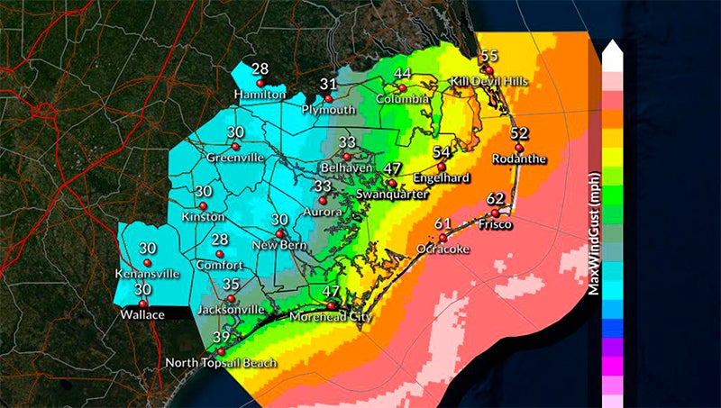
- NOR’EASTER: Sustained winds of 20 to 25 mph with gusts of up to 35 mph are expected Saturday in a storm system that will bring 72 hours of wind and rain to eastern North Carolina. (National Weather Service)
A wet and windy weekend is in store for Beaufort County.
A nor’easter moved into the area early Friday and will continue to batter the region through sunrise Sunday, according to the National Weather Service’s Newport/Morehead City office.
Areas west of Blounts Creek and Bath can expect to see 1 1/2 to 2 inches of rain; areas east of there, may see 2 to 3 inches.
While the heaviest rainfall is expected throughout the day Friday, north-northeast winds will peak on Saturday. Meteorologists are forecasting sustained winds between 15 to 20 mph by sunrise Saturday; later that day, 20 to 25 mph sustained winds are possible, along with gusts of 30 to 35 mph. Areas along the Pamlico River and Pungo River shore lines will be especially susceptible to these higher wind ranges.
“It’s going to be almost 72 hours of some pretty good wind,” said Chris Newkirk, chief of fire/emergency management with Beaufort County Emergency Services. “We’re not expecting anything major — it’s just going to be a messy weekend with some decent sustained winds all weekend long.”
North-northwest winds are expected to be less than 10 mph by sunrise Monday and continue to subside throughout the day, according to Newkirk.
The NWS forecast is also calling for 5-to-7-foot seas in the Pamlico Sound, 2-foot seas in the Pamlico and Pungo rivers; and the possibility of minor flooding. Coastal Carolina appears to bear the brunt of the nor’easter, as meteorologists say there is a potential for life-threatening storm surge, 2 to 4 feet above ground, beach erosion and ocean overwash along the Outer Banks. Many of the places at risk are still recovering from historic flooding, beach erosion and road washouts caused by Hurricane Dorian on Sept. 6.
Newkirk said Beaufort County Emergency Services will be monitoring the system throughout the weekend and will release any changes to the current forecast.
More Beaufort County


-
Polls
 Loading ...
-
-