NOAA unveils new tools for hurricane season
Published 8:11 pm Tuesday, June 30, 2020
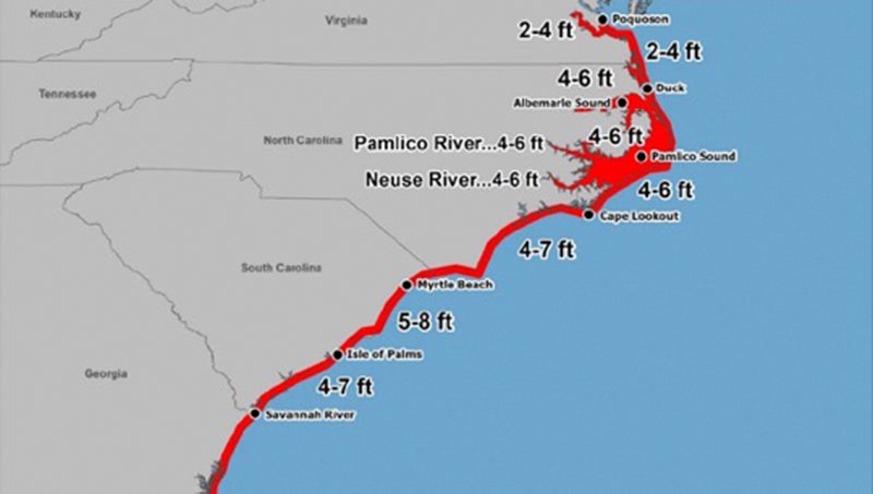
- STORM SURGE: New graphic updates from the National Weather Service will give the public a more concise understanding of storm-surge risk in the path of a hurricane. Where before risk was categorized as “elevated, moderate or high,” now graphics will show actual storm surge predictions in feet. (National Oceanic and Atmospheric Administration)
|
Getting your Trinity Audio player ready...
|
The National Weather Service and National Hurricane Center have re-envisioned how to get critical information to the public as hurricane season bears down on the East Coast.
In the wake of devasting storms such as Dorian, Irma, Maria and Michael in the past several years, NWS and NHC parent agency National Oceanic and Atmospheric Administration has revised graphics, increased notifications, streamlined information and created a social media presence to keep the public informed.
“I think it allows us to get the information to the public in a format that’s kind of easy to understand at a glance. It’s good to see that from the weather service and NOAA. The information has always been there, but you’ve had to find it,” said Chris Newkirk, deputy director of Beaufort County Emergency Services. “It’s just so much easier to understand and share with the public. That part’s very nice.”
One of the major changes is how the National Hurricane Center storm-surge predictions are shared. In the past, maps of coastal and low-lying areas have been portrayed by less specific threat levels: elevated, moderate or high. This year, the NHC will map out more precise ranges, illustrating expected storm-surge inundation — the peak height the water could reach above normally dry ground in the specified area — by feet.
NHC will also be issuing 60-hour track, intensity and wind forecasts, midway between the 72-hour and 48-hour forecasts previously provided. The more specific information about a hurricane’s track potentially gives those who need to prepare an additional 12 hours to do so.
“Getting that storm-surge notice a little earlier as to what is expected will be beneficial to local property owners, for sure,” said Melissa Beacham, BCES emergency services specialist. “Any advance warning is going to be beneficial.”
The more precise forecasts will be incorporated with the graphic updates NWS began releasing during the 2019 hurricane season. The graphics, combined with concise summary, have made BCES’ ability to share information with the public through email and social media, according to Newkirk.
“For our updates, we were reading all the summaries and forecast notes, then make our summary of it. With the amount of time it was taking to compile that email and get it out there every day — this makes it a lot easier,” Newkirk said.
NOAA is also seeking opinion on the NWS’ “Hazard Simplification Project,” through a public survey. Haz Simp proposes doing away with the word advisory and changing the language to a simple two-tier system “where the NWS only ‘raises the flag for the big events,’” according to the NWS website. The tiers would be whittled down to “Watch,” a prompt to prepare, and “Warning,” a prompt to act, in response to significant weather hazards that threaten life and/or property. That survey can be found at www.surveymonkey.com/r/publichazsimp.
For fans of social media, the NHC now has a presence on Facebook at www.facebook.com/NWSNHC and several Twitter accounts. The main account, @NWSNHC covers general topics such as education, outreach and fun facts. An operational feed for the Atlantic Basin, @NHC_Atlantic, will send automated tweets whenever NHC issues advisories and updates for tropical cyclones. The NHC storm surge group can be followed on Twitter at @NHC_Surge, and the Tropical Analysis and Forecast Branch, which focuses on marine forecasts, can be found at @NHC_TAFB.
More Beaufort County


SportsPlus
How to Watch MLB Baseball on Saturday, August 31: TV Channel, Live Streaming, Start Times
The Los Angeles Dodgers and the Arizona Diamondbacks square off in one of many compelling matchups on the…
How to Watch the WNBA Today | August 31
Today’s WNBA slate includes just one contest — the Connecticut Sun against the Washington Mystics. The WNBA is…
WNBA Betting Picks: Saturday, August 31
Wondering how you should bet on today’s WNBA game? Look no further. Below you’ll find computer predictions on…
Where to Watch East Carolina vs. Norfolk State on TV or Streaming Live – August 31
The Norfolk State Spartans (0-1) will visit the East Carolina Pirates on Saturday at 6:00 p.m. ET. We…
Washington Mystics vs. Connecticut Sun Betting Odds and Matchup Preview – Saturday, August 31
The Washington Mystics (9-22) will try to build on a three-game winning streak when hosting the Connecticut Sun…
-
Polls
 Loading ...
-
-