Severe weather possible for Christmas
Published 4:12 pm Wednesday, December 23, 2020
|
Getting your Trinity Audio player ready...
|
From CHRIS NEWKIRK, Beaufort County Emergency Services:
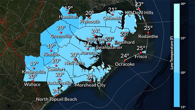
Beaufort County was upgraded to an ”Enhanced” storm threat category in this afternoon’s briefing from the National Weather Service (NWS). (Meaning numerous severe storms are possible) This latest update also includes a flood inundation forecast of 1 – 2’ for areas along the Pamlico and Pungo Rivers.
Please see the overview below and attached briefing from the NWS for additional details. Their next update is scheduled for 7 a.m. tomorrow morning.
A strong cold front is expected to affect the region Christmas Eve into Christmas Day with severe weather in the form of damaging wind gusts and tornadoes possible, as well as minor to moderate coastal flooding, and strong gradient wind with the potential for power outages.
A quick overview of the multiple changes since the last briefing:
1.) The entire area has been upgraded to an Enhanced Risk (Level 3 of 5) of severe thunderstorms for tomorrow. An increase in the tornado risk prompted the higher threat level.
2.) Coastal Flood Warnings have been hoisted for the Outer Banks, as well as Coastal Flood Advisories for coastal areas adjacent to the northern Pamlico Sound, Crystal Coast, and Pamlico and Pungo Rivers.
3.) A High Wind Warning has been issued for Hatteras and Ocracoke Islands, with a Wind Advisory issued for surrounding coastal areas.
More Weather


SportsPlus
Hawks vs. Hornets Injury Report Today – October 25
Here’s a look at the injury report for the Atlanta Hawks (1-0), which currently has four players listed,…
Will Sebastian Aho Score a Goal Against the Flames on October 24?
Will Sebastian Aho score a goal when the Carolina Hurricanes face off against the Calgary Flames on Thursday…
Will Martin Necas Score a Goal Against the Flames on October 24?
On Thursday at 9:00 PM ET, the Carolina Hurricanes go head to head against the Calgary Flames. Is…
Will Andrei Svechnikov Score a Goal Against the Flames on October 24?
Should you wager on Andrei Svechnikov to light the lamp when the Carolina Hurricanes and the Calgary Flames…
Will Seth Jarvis Score a Goal Against the Flames on October 24?
For people looking to wager on the upcoming battle between the Carolina Hurricanes and the Calgary Flames on…
-
Polls
 Loading ...
-
-