Hurricane Ian: Sept. 27 AM update
Published 10:32 am Tuesday, September 27, 2022
|
Getting your Trinity Audio player ready...
|
From Chris Newkirk, Beaufort County Emergency Services
Please see below and attached briefing for the latest update from the NWS.
As previously mentioned, there continues to be subtle differences between the forecast models so far, which drastically change the forecasted impacts for Beaufort County. For example. The ECMWF (Euro) suggests a more inland track for impacts from Florida through the Eastern US, keeping most of the rain south and west of our area. However, the GFS suggests a more eastern track for impacts, bringing more rain and wind to us. We are hopeful that many of the differences seen between forecast models will be resolved today, as Ian moves over Cuba and begins to interact with some of weather variables that have been forecasted to steer and / or cause Ian to gain / loss strength. With all this being said, it is important that we continue to monitor the progression of Ian over the coming days. Please use this time to ensure that you, your family, friends and neighbors are prepared for any possible impacts that may come our way, especially heavy rains, persistently high winds, power outages, etc..
Minor changes continue to be made to the forecasted rainfall and timing for Beaufort County. These changes have been highlighted below.
Rain
- 4 to 6 inches of rain is forecasted for our area. Our greatest chance of rain and highest hourly accumulation is currently forecasted to occur during the daylight hours Saturday. Heavy downpours capable of causing localized flash flooding is possible during this time.
Winds
- Winds are currently forecasted to be sustained between 15 and 20 mph Thursday through Saturday, with gust of 25 – 35 mph possible Thursday through Saturday.
We will continue to pass along information as we receive it.
From the NWS Newport/Morehead City:
Ian has strengthened into a Major Hurricane this morning, and has made landfall over western Cuba. Hurricane Ian is expected to continue north into the Gulf of Mexico today, and then make landfall on the Florida peninsula early Thursday morning. There have been some slight changes in the first 48-60 hours of the track forecast, however the expected position of Ian through the rest of the Southeast US remains largely unchanged.
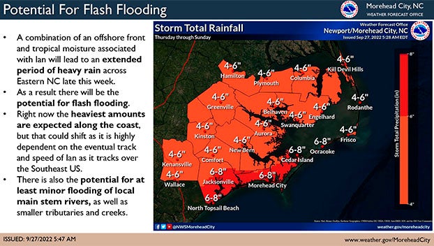
Confidence continues to increase that Eastern NC will feel impacts from this system, with the greatest local threats being heavy rainfall and the potential for flash flooding, as well as coastal flooding.
It remains too early for specific details regarding severity and timing of the coastal flooding impacts, but we will continue to update as forecast confidence and probabilities increase.
Rainfall totals have increased ever so slightly, and we continue to expect the heaviest rainfall along the coast. However, please be aware that the rainfall forecast is highly dependent on the eventual track and speed of Ian through the Southeast US, and the area of maximum rainfall may shift.
We will monitor the progress and evolution of this system and will provide additional briefings as the forecast warrants.
Please see the attached briefing for additional details. Remember, you can monitor conditions in the tropics at https://www.weather.gov/mhx/tropical.
NWS Morehead City Hurricane Ian Briefing #7 Sep 27th 2022
More Weather


SportsPlus
How to Watch the WNBA Today | August 31
Today’s WNBA slate includes just one contest — the Connecticut Sun against the Washington Mystics. The WNBA is…
WNBA Betting Picks: Saturday, August 31
Wondering how you should bet on today’s WNBA game? Look no further. Below you’ll find computer predictions on…
Where to Watch East Carolina vs. Norfolk State on TV or Streaming Live – August 31
The Norfolk State Spartans (0-1) will visit the East Carolina Pirates on Saturday at 6:00 p.m. ET. We…
Washington Mystics vs. Connecticut Sun Betting Odds and Matchup Preview – Saturday, August 31
The Washington Mystics (9-22) will try to build on a three-game winning streak when hosting the Connecticut Sun…
Where to Watch Washington Mystics vs. Connecticut Sun on TV or Streaming Live – Saturday, August 31
The Washington Mystics (9-22) will try to extend a three-game winning stretch when hosting the Connecticut Sun (22-8)…
-
Polls
 Loading ...
-
-