Hurricane Ian: Sept. 27 PM update
Published 6:01 pm Tuesday, September 27, 2022
|
Getting your Trinity Audio player ready...
|
From Chris Newkirk, Beaufort County Emergency Services
Please see the below and attached briefing for the latest update from the NWS.
We are monitoring a trending shift to the east with the forecasted track, which would place the center of Ian close to re-emerging in the Atlantic near Daytona Beach Florida, before continuing northeast along the Georgia / Southern South Carolina coast. As mentioned, these subtle changes in Ian’s track impact the forecast for our area.
This recent update has led to changes in the timing of rainfall and wind for our area. Those changes have been highlighted below.
Rain
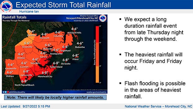
- 4 to 6 inches of rain is forecasted for our area. Our greatest chance of rain and highest hourly accumulation is currently forecasted to occur Friday afternoon and Saturday. Heavy downpours capable of causing localized flash flooding is possible during this time.
Winds
- Winds are currently forecasted to be sustained between 15 and 20 mph Wednesday through Saturday, with gust of 25 – 35 mph possible Thursday through Saturday.
Storm Surge
- The sustained winds that are forecasted for our area will result in storm surge along our county’s waterways, especially along the Pamlico and Pungo Rivers. We are working to gather information pertaining to this impact with hopes of sharing forecasted values in tomorrow afternoon’s update.
We will continue to pass along information as we receive it.
From the NWS Newport/Morehead City:
Ian continues to show signs of strengthening and is expected to continue it’s motion north into the Gulf of Mexico today, pass west of the Florida Keys tonight, and then approach the west coast of the Florida peninsula Wednesday and Wednesday night. There have been some slight changes in the 1 to 3 day track forecast. Currently, the center of Hurricane Ian is forecast to near the northern East Coast of Florida Friday while weakening to a Tropical Storm, and begin a slight north-northwesterly turn into Georgia and continuing into South Carolina Friday night and Saturday, further weakening into a Tropical Depression.
Confidence continues to increase that Eastern NC will feel impacts from this system, with the greatest local threats being heavy rainfall and the potential for flash flooding, as well as coastal flooding.
It remains too early for specific details regarding severity and timing of the coastal flooding impacts, but we will continue to update as forecast confidence and probabilities increase.
There have been minuscule changes to rainfall totals, and we continue to expect the heaviest rainfall along the coast. However, please be aware that the rainfall forecast is highly dependent on the eventual track and speed of Ian through the Southeast US, and the area of maximum rainfall may shift.
We will monitor the progress and evolution of this system and will provide additional briefings as the forecast warrants.
Please see the attached briefing for additional details. If you have any questions, don’t hesitate to contact us at (252) 223-5737 Ext. 6. Remember, you can monitor conditions in the tropics at https://www.weather.gov/mhx/tropical.
NWS Morehead City Hurricane Ian Briefing #8 Sep 27th 2022
More Weather


SportsPlus
How to Watch MLB Baseball on Friday, July 26: TV Channel, Live Streaming, Start Times
The Cleveland Guardians versus the Philadelphia Phillies is a game to watch on a Friday MLB schedule that…
Carolina Panthers vs. Arizona Cardinals Week 16 Tickets Available – Sunday, December 22 at Bank of America Stadium
On Sunday, December 22, 2024, the Arizona Cardinals (0-0) meet the Carolina Panthers (0-0) at Bank of America…
Carolina Panthers vs. Dallas Cowboys Week 15 Tickets Available – Sunday, December 15 at Bank of America Stadium
The Dallas Cowboys (0-0) travel to Bank of America Stadium on Sunday, December 15, 2024 to take on…
Carolina Panthers vs. Philadelphia Eagles Week 14 Tickets Available – Sunday, December 8 at Lincoln Financial Field
On Sunday, December 8, 2024, the Philadelphia Eagles (0-0) and the Carolina Panthers (0-0) clash at Lincoln Financial…
Carolina Panthers vs. Chicago Bears Week 5 Tickets Available – Sunday, October 6 at Soldier Field
Soldier Field is where the Carolina Panthers (0-0) will trade blows with the Chicago Bears (0-0) on Sunday,…
-
Polls
 Loading ...
-
-