Hurricane Ian: Sept. 28 AM update
Published 11:40 am Wednesday, September 28, 2022
|
Getting your Trinity Audio player ready...
|
From Chris Newkirk, Beaufort County Emergency Services
Please see below and attached briefing for the latest update from the NWS.
This recent update has provided us with additional information, which has been highlighted below.
Rain
- 4 to 6 inches of rain is forecasted for our area. Our greatest chance of rain and highest hourly accumulation is currently forecasted to occur Friday afternoon and Saturday. Heavy downpours capable of causing localized flash flooding is possible during this time.
Winds
- Winds are currently forecasted to be sustained between 15 and 20 mph Wednesday through Saturday, with gust of 25 – 35 mph possible Thursday through Saturday.
Storm Surge
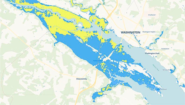
- A Coastal Flood Watch has been issued for Beaufort County, as persistent NE winds are capable of causing 1 to 3 feet of inundation to the coastal areas of the Pamlico and Pungo Rivers. (See the attached titled “9/28/22 AM Surge Maps” for a visual of these areas.) Note: These values and maps may change with future updates.
The next update from the NWS is scheduled for 6pm today. We will continue to pass along information as we receive it.
From NWS Newport/Morehead City:
Ian is now a strong Category 4 hurricane located about 75 miles WSW of Naples, FL. No major changes were made to the forecast track overnight – Ian is still expected to make landfall today along the west coast of Florida, around the Port Charlotte area, and slowly track NE across central FL tonight and Thursday. The current forecast brings Ian off the east coast of FL and back out into the Atlantic as a Tropical Storm Thursday night where it will begin a slight NNW turn towards Georgia/South Carolina Friday where a second landfall is likely, eventually becoming a Tropical Depression. As Ian impacts the GA/SC region, it will interact with a strong frontal boundary that will create strong NE winds and heavy rainfall for eastern NC.
Confidence continues to increase that Eastern NC will feel impacts from this system, with the greatest local threats being heavy rainfall and the potential for flash flooding, as well as coastal flooding.
Changes from last briefing:
- Coastal Flood Watch issued for areas around SW Pamlico Sound, Neuse & Bay Rivers, and Pamlico & Pungo Rivers.
- Upgraded to Gale Warnings for southern coastal waters; issued additional Gale Watch for northern coastal waters
- SPC has added portions of eastern NC into a Marginal Risk for severe weather on Friday
No major changes have been made to the rainfall forecast – we are still expecting a general 4-8 inches of rain Thursday through Saturday with heavier amounts possible along the coast. Please be aware that the rainfall forecast is highly dependent on the eventual track and speed of Ian through the Southeast US, and the area of maximum rainfall may shift.
Greatest risk for coastal flooding will be along the southern/western Pamlico Sound, Neuse & Bay Rivers, and Pamlico & Pungo Rivers. Other areas of concern include Oceanside OBX, Core Sound, Bogue Sound, and Oceanside Crystal Coast, though it remains too early for specific impacts in these areas at this time. Additional watches, warnings, and/or advisories will be issued as needed.
We will monitor the progress and evolution of this system and will provide additional briefings as the forecast warrants.
Please see the attached briefing for additional details. If you have any questions, don’t hesitate to contact us at (252) 223-5737 Ext. 6. Remember, you can monitor conditions in the tropics at https://www.weather.gov/mhx/tropical.
9-28-22 AM Surge Maps NWS Morehead City Hurricane Ian Briefing #9 Sep 28th 2022
More Weather


SportsPlus
How to Watch MLB Baseball on Friday, July 26: TV Channel, Live Streaming, Start Times
The Cleveland Guardians versus the Philadelphia Phillies is a game to watch on a Friday MLB schedule that…
Carolina Panthers vs. Arizona Cardinals Week 16 Tickets Available – Sunday, December 22 at Bank of America Stadium
On Sunday, December 22, 2024, the Arizona Cardinals (0-0) meet the Carolina Panthers (0-0) at Bank of America…
Carolina Panthers vs. Dallas Cowboys Week 15 Tickets Available – Sunday, December 15 at Bank of America Stadium
The Dallas Cowboys (0-0) travel to Bank of America Stadium on Sunday, December 15, 2024 to take on…
Carolina Panthers vs. Philadelphia Eagles Week 14 Tickets Available – Sunday, December 8 at Lincoln Financial Field
On Sunday, December 8, 2024, the Philadelphia Eagles (0-0) and the Carolina Panthers (0-0) clash at Lincoln Financial…
Carolina Panthers vs. Chicago Bears Week 5 Tickets Available – Sunday, October 6 at Soldier Field
Soldier Field is where the Carolina Panthers (0-0) will trade blows with the Chicago Bears (0-0) on Sunday,…
-
Polls
 Loading ...
-
-