Coastal flooding expected from Tropical Storm Nicole
Published 5:53 pm Tuesday, November 8, 2022
|
Getting your Trinity Audio player ready...
|
From Chris Newkirk / Beaufort County Emergency Services:
Our office is currently monitoring two weather events that will continue to impact our area through Saturday.
First, a high pressure system will continue to bring sustained NE winds between 10 and 15 mph, with frequent gust between 20 and 25 mph to our area through noon on Thursday. Our highest winds associated with this system are forecasted to occur during the daylight hours tomorrow (Wednesday). These conditions are expected to keep our waterways 1 to 2 feet above normal.
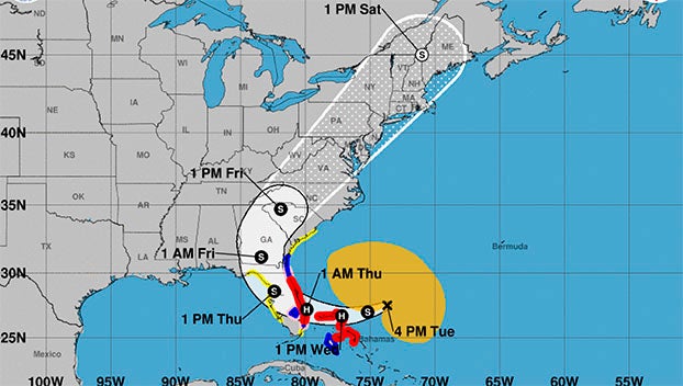
Remnants of Tropical System Nicole is expected to move through North Carolina Thursday night / Friday, impacting Beaufort County as follows.
Rain
- Rain chances begin to increase after 7pm Thursday night and continue through sunrise Saturday morning, with 1 to 1 ½ inches currently forecasted for our area.
- Our greatest chance of rain is currently forecasted to occur between 7am and 7pm Friday.
Winds
- Sustained winds between 10 and 20 mph, with frequent gust up to 35 mph are expected from 7pm Thursday through sunrise Saturday morning.
- Our highest winds are forecasted to occur between 7am and midnight Friday. (This is especially true between 4pm and 7pm Friday.)
Severe Thunderstorms / Tornados
- Strong to severe thunderstorms, as well as isolated tornados are possible Thursday night and Friday as bands associated with Nicole move through our area.
Please see below and attached briefing from the National Weather Service for additional information:
From NWS Newport/Morehead City:
We are continuing to monitor multiple weather events which will impact Eastern NC this week.
1) Strong NE winds will continue between strong high pressure building in from the north and Tropical Storm Nicole to the south. This will lead to an extended period of winds 25-35 mph sustained winds with gusts up to 50 mph across coastal Eastern NC. As a result of these winds, minor to locally moderate coastal flooding will be possible, as well as the potential for ocean overwash and beach erosion. These threats will likely continue into Thursday morning.
2) Tropical Storm Nicole is expected to strengthen over the next few days making landfall across the Florida Peninsula, and then is expected to move up the interior SE US late this week. There is increasing likelihood that the system, or remnants of the system, will impact Eastern NC by late Thursday night into Friday evening, bringing strong southerly gale force winds, additional coastal flooding, a period of locally heavy rain, and isolated tornadoes.
Attached is the first full briefing for the ongoing coastal threats and Nicole.
NWS Morehead City Coastal Flooding & TC Nicole Briefing #4
More Weather


SportsPlus
How to Watch the WNBA Today | September 1
Today’s WNBA slate has five exciting matchups on the docket. Among those games is the Seattle Storm taking…
WNBA Betting Picks: Sunday, September 1
Need help with your wagers on today’s WNBA slate? Don’t worry. You’ll find computer predictions for the spread…
How to Watch MLB Baseball on Saturday, August 31: TV Channel, Live Streaming, Start Times
The Los Angeles Dodgers and the Arizona Diamondbacks square off in one of many compelling matchups on the…
How to Watch the WNBA Today | August 31
Today’s WNBA slate includes just one contest — the Connecticut Sun against the Washington Mystics. The WNBA is…
WNBA Betting Picks: Saturday, August 31
Wondering how you should bet on today’s WNBA game? Look no further. Below you’ll find computer predictions on…
-
Polls
 Loading ...
-
-