Weather pattern could bring high winds, cold temperatures
Published 12:02 pm Monday, December 19, 2022
|
Getting your Trinity Audio player ready...
|
From Chris Newkirk, Beaufort County Emergency Services:
Our office is currently monitoring the development of a weather pattern that is expected to impact our area over the next 7 to 10 days. It appears that high winds Thursday and Friday, as well as cold temperatures this weekend and next week will be our greatest hazards. Current forecast details are as follows:
- Wednesday, Thursday and Friday will be the warmest days of this pattern, with high temps in the 50s – 60s.
- Rain will be moving into the area by mid-morning Thursday and continue through noon Friday. Most areas are forecasted to get about an inch of rain during this time.
-
- There is a chance of severe storms occurring between 8p and midnight on Thursday as well.
- S / SW winds will begin to pick up Thursday becoming sustained between 10 and 15 mph, with frequent gust of 20 to 25mph. These winds will increase again on Friday, becoming sustained between 20 and 25 mph, with gust of 40 to 45 mph possible, especially during the afternoon hours.
- The temperatures are going to drop quickly Friday afternoon, with highs struggling to get above freezing through Monday. Wind chills are expected to remain in the teens and twenties Christmas Eve and Christmas Day.
- Temperatures are currently forecasted to remain lower than normal for the remainder of next week, with highs in the 40s – 50s and lows at or below freezing at night.
- The latest model runs are suggesting that all forms of winter precipitation will remain north and west of NC.
Please see the attached briefing and email below for the National Weather Service’s first update related to this weather pattern.
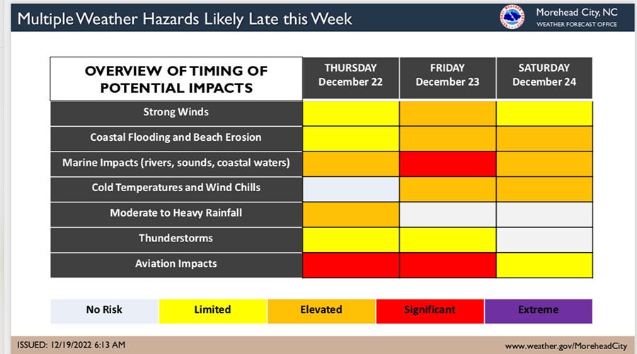
From the National Weather Service, Newport/Morehead City:
Confidence continues to increase regarding a strong weather system that is forecast to bring multiple hazards to much of the Eastern United States later this week. Attached is a 2-page overview of the potential hazards for Eastern North Carolina as well as a general overview of the timing of impacts.
Additional updates will be sent as forecast confidence evolves through the week.
NWS Morehead City Multiple Hazards 2 Pager #1 December 22-24 2022
More Weather


SportsPlus
How to Watch MLB Baseball on Saturday, August 31: TV Channel, Live Streaming, Start Times
The Los Angeles Dodgers and the Arizona Diamondbacks square off in one of many compelling matchups on the…
How to Watch the WNBA Today | August 31
Today’s WNBA slate includes just one contest — the Connecticut Sun against the Washington Mystics. The WNBA is…
WNBA Betting Picks: Saturday, August 31
Wondering how you should bet on today’s WNBA game? Look no further. Below you’ll find computer predictions on…
Where to Watch East Carolina vs. Norfolk State on TV or Streaming Live – August 31
The Norfolk State Spartans (0-1) will visit the East Carolina Pirates on Saturday at 6:00 p.m. ET. We…
Washington Mystics vs. Connecticut Sun Betting Odds and Matchup Preview – Saturday, August 31
The Washington Mystics (9-22) will try to build on a three-game winning streak when hosting the Connecticut Sun…
-
Polls
 Loading ...
-
-