Gale Warning issued for Beaufort County
Published 9:27 am Saturday, April 1, 2023
|
Getting your Trinity Audio player ready...
|
From Chris Newkirk / Beaufort County Emergency Services:
The latest update from the National Weather Service included a minor changes to the timing of today’s rain and severe weather threats. These changes have been highlighted below:
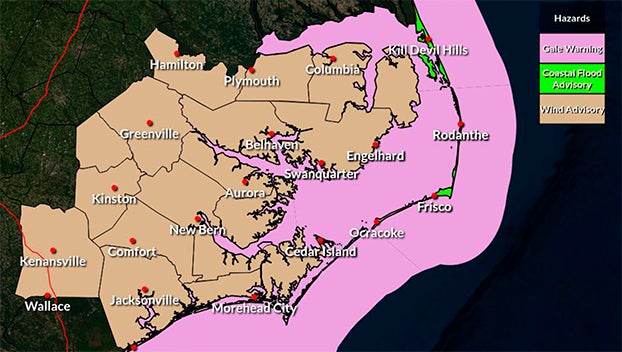
Current Beaufort County Forecast
Winds
South winds are expected to increase Friday and remain elevated through noon on Sunday as follows:
- Saturday: S winds transitioning to SW sustained between 20 and 25 mph, with gust of 35 – 45 mph. (Especially between 9am and 6pm)
- A Gale Warning has been issued for Beaufort County’s waterways.
- Sunday: SW winds transitioning to the N sustained between 10 and 15 mph, with gust of 15 to 25 through noon.
Rain & Severe Weather
- There is a chance of rain between 2pm and 5pm today, with most areas forecasted to receive less than ¼ of an inch.
- There is a 20% chance of strong to marginally severe storms capable of producing locally enhanced wind damage, with the greatest risk of these storms occurring between 2pm and 5pm today.
Please see the email below and attached briefing from the National Weather Service for more information.
This will be the last update associated with this weather event. We encourage everyone to monitor local media outlets for any watches and / or warnings that may be issued.
From the National Weather Service / Morehead City:
Confidence on impacts from tomorrow’s strong cold front continue to increase, with the latest briefing outlining these impacts in more detail.
WHAT’S NEW
* Wind Advisories expanded for all of Eastern NC with 45-50 mph gusts expected.
* Gale Warnings expanded for all marine waterways.
* Coastal Flood Advisory Issued for Northern Hatteras Island and much of the Northern Outer Banks.
This will be the last briefing unless significant changes are made to the forecast or headlines.
NWS Morehead City – Briefing 5 – April 1st Strong Cold Front
More Weather


SportsPlus
How to Watch MLB Baseball on Saturday, August 31: TV Channel, Live Streaming, Start Times
The Los Angeles Dodgers and the Arizona Diamondbacks square off in one of many compelling matchups on the…
How to Watch the WNBA Today | August 31
Today’s WNBA slate includes just one contest — the Connecticut Sun against the Washington Mystics. The WNBA is…
WNBA Betting Picks: Saturday, August 31
Wondering how you should bet on today’s WNBA game? Look no further. Below you’ll find computer predictions on…
Where to Watch East Carolina vs. Norfolk State on TV or Streaming Live – August 31
The Norfolk State Spartans (0-1) will visit the East Carolina Pirates on Saturday at 6:00 p.m. ET. We…
Washington Mystics vs. Connecticut Sun Betting Odds and Matchup Preview – Saturday, August 31
The Washington Mystics (9-22) will try to build on a three-game winning streak when hosting the Connecticut Sun…
-
Polls
 Loading ...
-
-