Updated forecast for Memorial Day weekend
Published 10:20 am Thursday, May 25, 2023
|
Getting your Trinity Audio player ready...
|
From Beaufort County Emergency Services:
This morning’s update from the National Weather Service included minor changes to wind values as well as the timing of this weekend’s impacts. Those changes have been highlighted below.
Current forecast details for Beaufort Co.
Winds
- NE winds will begin to increase Thursday morning, becoming sustained between 10 and 15 mph with frequent gust between 20 and 25 mph. Winds will increase again on Friday, becoming sustained between 15 and 20 mph with gust between 25 and 30 mph possible through midnight Saturday.
- Our highest winds are expected to occur between 10am and 7pm Saturday.
Rain
- Rain will begin to move into the area overnight Friday, with most areas receiving rain by sunrise Saturday. Rain will remain in the forecast through Monday with most areas of our county receiving 2 inches.
- Our heaviest rains are expected to occur between 8am and 8pm Saturday.
Thunderstorms
- Thunderstorms are possible with this event, and are most likely to occur between the hours of 2pm and 1am Saturday afternoon / Sunday morning and again during the same time period on Sunday afternoon / Monday morning.
Please see the email below and attached briefing from the National Weather Service for more information. Their next briefing is scheduled for 10am tomorrow morning. We will continue to pass along information as we receive it.
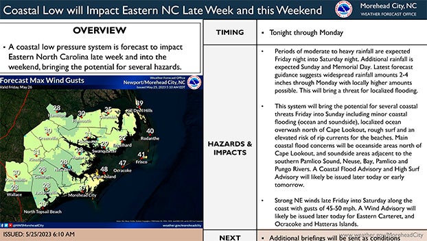
From the National Weather Service, Morehead City:
A slow moving, developing low pressure system offshore, is forecast to come ashore into the Carolinas Saturday or Sunday. This low will bring widespread showers/possible thunderstorms with heavy rains and strong northeasterly winds to eastern NC beginning tonight and continuing into the Memorial Day weekend.
Some impacts expected form this system include:
Rainfall of 2-4″ with locally heavier amounts possible through Memorial Day (Monday).
Gale Force Winds with seas building to 10-15 ft Friday night into Saturday.
The strong winds will also result in rough surf, minor coastal flooding (ocean and sound side), localized ocean over wash north of Cape Lookout, and an elevated rip current risk for the beaches.
The main coastal flood concerns will be oceanside north of Cape Lookout, and sound side adjacent to the southern Pamlico Sound, Neuse, Bay, Pamlico, and Pungo Rivers.
Strong NE winds with gusts of 45-50 mph across Eastern Carteret, and Ocracoke and Hatteras Islands.
NWS Morehead City Multiple Hazards 1 Pager #2 May 24 2023
More Weather


SportsPlus
How to Watch the MLB Baseball Playoffs on Sunday, Oct. 6: TV Channel, Live Streaming, Start Times
The San Diego Padres and the Los Angeles Dodgers take the field for one of many exciting matchups…
How to live stream NFL RedZone Week 5 with a free Fubo trial
Football fans, want to watch all of the NFL action this week? Forget flipping back and forth between…
MLB Playoff Betting Lines and Picks Today | Oct. 6
The San Diego Padres and the Los Angeles Dodgers hit the field in one of many exciting matchups…
How to Watch the WNBA Playoffs Today | Oct. 6
On a Sunday WNBA playoff slate that features two exciting matchups, the New York Liberty versus the Las…
WNBA Betting Picks: Sunday, Oct. 6
Wondering how you should bet on today’s WNBA games? Look no further. Below you’ll find computer predictions on…
-
Polls
 Loading ...
-
-