Coastal Flood Advisory for Memorial Day Weekend
Published 10:39 am Friday, May 26, 2023
|
Getting your Trinity Audio player ready...
|
From Chris Newkirk / Beaufort County Emergency Services:
This morning’s update from the National Weather Service included a Coastal Flood Advisory for Beaufort County, as well as minor changes to the timing of this weekend’s impacts. Those changes have been highlighted below.
Current forecast details for Beaufort Co.
Coastal Flood Advisory
- Waterways along the Pamlico River are expected to be 2 to 3 feet higher than normal through the weekend.
- Areas susceptible to prolonged northeast winds could experience water levels 3 to 4 higher than normal late Saturday evening / night.
Winds
- Winds will remain sustained between 15 and 20 mph with gust between 25 and 30 mph through midnight Saturday.
- Our highest winds are expected to occur between 12pm and 5pm today as well as 7am to 7p tomorrow.
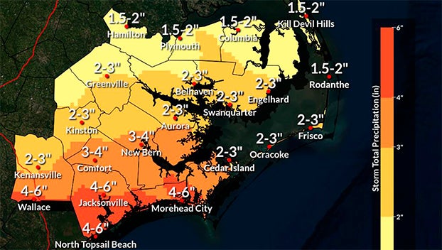
Rain
- Rain will begin to move into Beaufort County early tomorrow morning, with most areas receiving rain by 8am. Rain will remain in the forecast through Monday with areas along and north of Hwy 264 receiving 1 ½ to 2 inches of rain, and areas south receiving 2 to 3 inches.
- Our heaviest rains are expected to occur between 2pm Saturday and 8am Sunday.
Thunderstorms
- Thunderstorms are possible with this event, and are most likely to occur between the hours of 1pm Saturday and 7am Sunday morning.
Please see below and attached briefing from the National Weather Service for more information.
From the National Weather Service / Morehead City:
Attached is the latest briefing for a coastal storm bringing multiple hazards to eastern North Carolina for Memorial Day weekend.
Key Messages
- Moderate to locally major impacts due to soundside coastal flooding are expected through early Monday. for the SW Pamlico Sound as well as the Nuese, Bay, and Pamlico Rivers. Dangerous surf conditions are expected for area beaches from Cape Lookout to Duck.
- Strong winds are expected along coastal areas through tomorrow evening causing potentially minor damage and isolated power outages.
- Heavy rainfall of up to 4-6 inches is forecast along the Crystal Coast, but a widespread minimum of 1-2 inches is likely for our entire area.
What Has Changed
- The High Surf Advisory was extended to Ocracoke Island
NWS Morehead City Briefing #4 Multiple Hazards May 26th 2023
More Weather


SportsPlus
How to Watch MLB Baseball on Saturday, August 31: TV Channel, Live Streaming, Start Times
The Los Angeles Dodgers and the Arizona Diamondbacks square off in one of many compelling matchups on the…
How to Watch the WNBA Today | August 31
Today’s WNBA slate includes just one contest — the Connecticut Sun against the Washington Mystics. The WNBA is…
WNBA Betting Picks: Saturday, August 31
Wondering how you should bet on today’s WNBA game? Look no further. Below you’ll find computer predictions on…
Where to Watch East Carolina vs. Norfolk State on TV or Streaming Live – August 31
The Norfolk State Spartans (0-1) will visit the East Carolina Pirates on Saturday at 6:00 p.m. ET. We…
Washington Mystics vs. Connecticut Sun Betting Odds and Matchup Preview – Saturday, August 31
The Washington Mystics (9-22) will try to build on a three-game winning streak when hosting the Connecticut Sun…
-
Polls
 Loading ...
-
-