Severe Weather threat for Beaufort County
Published 1:22 pm Wednesday, July 19, 2023
")
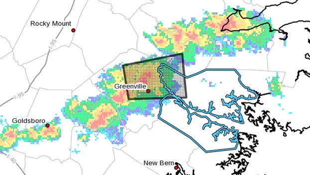
(National Weather Service)
|
Getting your Trinity Audio player ready...
|
NCZ080-081-094-192130-
Beaufort NC-Mainland Hyde NC-Pamlico NC-
452 PM EDT Wed Jul 19 2023
…A strong thunderstorm will impact portions of west central Hyde,
southeastern Beaufort and northeastern Pamlico Counties through 530
PM EDT…
At 452 PM EDT, Doppler radar was tracking a strong thunderstorm over
Goose Creek State Park, or near River Road, moving east at 40 mph.
HAZARD…Winds in excess of 40 mph.
SOURCE…Radar indicated.
IMPACT…Gusty winds could knock down tree limbs and blow around
unsecured objects.
Locations impacted include…
Washington, River Road, Sladesville, Ransomville, Scranton, Blounts
Creek, Pamlico Beach, Lowland, Edward, Cox Crossroads, Bonnerton,
Winsteadville, Core Point, South Creek, Bayview, Sidney Crossroads,
Yeatesville, Aurora Ferry Terminal, Goose Creek State Park and
Bayview Ferry Terminal.
PRECAUTIONARY/PREPAREDNESS ACTIONS…
If outdoors, consider seeking shelter inside a building.
A Tornado Watch remains in effect until 700 PM EDT for eastern North
Carolina.
&&
LAT…LON 3552 7639 3524 7641 3533 7702 3552 7700
TIME…MOT…LOC 2052Z 274DEG 35KT 3543 7692
MAX HAIL SIZE…0.00 IN
MAX WIND GUST…40 MPH
—
The National Weather Service in Newport has issued a
* Severe Thunderstorm Warning for…
Northeastern Pitt County in eastern North Carolina…
South central Martin County in eastern North Carolina…
Northwestern Beaufort County in eastern North Carolina…
* Until 430 PM EDT.
* At 341 PM EDT, a severe thunderstorm was located over House, or
near Greenville, moving east at 25 mph.
HAZARD…60 mph wind gusts and quarter size hail.
SOURCE…Radar indicated.
IMPACT…Hail damage to vehicles is expected. Expect wind damage
to roofs, siding, and trees.
* Locations impacted include…
Greenville, Washington, Stokes, House, Pactolus, Old Ford, East
Carolina University, Pitt Greenville Airport, Dowdy Ficklen
Stadium, Grimesland, Simpson, Smithwick and Beargrass.
PRECAUTIONARY/PREPAREDNESS ACTIONS…
A Tornado Watch remains in effect until 700 PM EDT for eastern North
Carolina.
For your protection move to an interior room on the lowest floor of a
building.
Please send your reports of hail and/or wind damage, including trees
or large limbs downed, by calling the National Weather Service office
in Newport at 1-800-889-6889.
A Tornado Watch remains in effect until 700 PM EDT for eastern North
Carolina.
&&
LAT…LON 3553 7741 3573 7745 3580 7702 3554 7699
TIME…MOT…LOC 1941Z 259DEG 23KT 3566 7734
HAIL THREAT…RADAR INDICATED
MAX HAIL SIZE…1.00 IN
WIND THREAT…RADAR INDICATED
MAX WIND GUST…60 MPH
—-
THE NATIONAL WEATHER SERVICE HAS ISSUED TORNADO WATCH 517 IN
EFFECT UNTIL 7 PM EDT THIS EVENING FOR THE FOLLOWING AREAS
IN NORTH CAROLINA THIS WATCH INCLUDES 6 COUNTIES
IN EASTERN NORTH CAROLINA
BEAUFORT DARE HYDE
MARTIN TYRRELL WASHINGTON
THIS INCLUDES THE CITIES OF AURORA, BATH, BELHAVEN, BUXTON,
CHOCOWINITY, COLUMBIA, CRESWELL, ENGELHARD, FAIRFIELD, GUM NECK,
JAMESVILLE, KITTY HAWK, MANTEO, NAGS HEAD, OAK CITY, OCRACOKE,
PLYMOUTH, ROBERSONVILLE, RODANTHE, ROPER, SCRANTON, STUMPY POINT,
SWANQUARTER, WASHINGTON, AND WILLIAMSTON.
More News


SportsPlus
How to Watch the NBA Today, November 9
In one of the four intriguing matchups on the NBA schedule today, the Brooklyn Nets and Cleveland Cavaliers…
November 9 NHL TV Schedule: TV Channel, Start Times & Live Streaming Options
In a Saturday NHL slate that features a lot of exciting contests, the Dallas Stars versus the Winnipeg…
NBA Spread and Total Picks for Today, November 9
The Utah Jazz versus the San Antonio Spurs is one of many solid options on today’s NBA slate.…
Top 25 College Hoops Picks Against the Spread – Saturday, November 9
Top 25 teams will be in action in six games on Saturday’s college basketball schedule. That includes the…
How to Pick the Hurricanes vs. Avalanche Game with Odds, Spread, Betting Line and Stats – November 9
Saturday’s NHL schedule includes a matchup between the Carolina Hurricanes and the Colorado Avalanche at Ball Arena, with…
-
Polls
 Loading ...
-
-