Tropical Storm Idalia: 08.28.23 p.m. update
Published 7:52 pm Monday, August 28, 2023
|
Getting your Trinity Audio player ready...
|
From Chris Newkirk, Beaufort County Emergency Services:
Our office is monitoring the development of Tropical Storm Idalia and it’s potential impacts to our area. The current forecast for Beaufort County is as follows.
Monday & Tuesday
- Passing showers that are unrelated to Idalia will continue to move through Beaufort County today and tomorrow with most areas receiving 1 to 1 ½ inches of rain by sunset Tuesday.
Wednesday & Thursday
- Rain
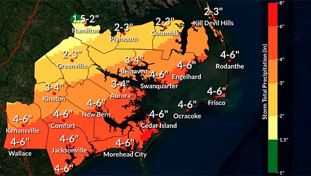
- Precipitation from Idalia will begin to move into our area Wednesday and continue through midnight Thursday. Accumulation will be largely dependent on the exact track of the storm. For example, most areas of Beaufort County would receive 2 to 4 inches of rain if Idalia continues to follow a more southeastern track as indicated by the current National Hurricane Center Forecast and European Forecast Model runs. However, if Idalia takes a more western track as indicated by the GFS Model, we could receive more than 4 inches of rain. (We hope that these models will be in more agreement with each other over the next 24 hrs.)
- Our heaviest rains are currently forecasted to occur between 2pm Wednesday afternoon and 8am Thursday morning, with rain exiting the our area by sunrise Friday.
- Winds
- Unlike rainfall totals, the various forecast models seem to agree on the winds that are being forecasted for Beaufort County, with most areas experiencing sustained winds of 20 to 25 mph with frequent gust of 35 to 40 mph.
- Our highest winds are currently forecasted to occur between 4am Thursday and 4am Friday.
- Severe Storms & Tornado
- As with many tropical weather systems, passing rain bands can result in severe thunderstorms capable of producing flash flooding as a result of heavy downpours and possible tornados. While severe storms are possible for all of Beaufort County Wednesday and Thursday, areas south and east of Belhaven, Bath and Blounts Creek will be at a slightly greater risk than other portions of our county.
- Storm Surge
- 1 to 3 feet of storm surge is expected along the shorelines of our county Wednesday night and Thursday.
Things to remember and look for:
- These forecasted conditions are dependent on the actual track Idalia takes as it moves across the Gulf of Mexico and the Southern US. A more southern / eastern track as currently indicated by the official forecast is more favorable to our area and well lessen the impacts we experience. (The system will move through our area faster with less rainfall and less overall time under inclement conditions.) A more northern / western track would be less favorable, and subject us to more inclement conditions for a longer period of time.
Please see below and attached briefing from the National Weather Service for additional information. We will continue to pass along information as we receive it. We also encourage everyone to continue to monitor local media outlets for more frequent updates.
From National Weather Service, Morehead City:
No big changes to the forecast. We have added significant details with the attached briefing with regards to all of the possible threats from Idalia. Continue to monitor for updates over the next few days.
We remain in a prolonged period of dangerous rip current/surf conditions and beach erosion as Major Hurricane Franklin passes offshore. Localized ocean over wash along the Outer Banks is also possible during this time.
NWS Morehead City Briefing #5 Idalia
More Weather


SportsPlus
How to Watch MLB Baseball on Saturday, August 31: TV Channel, Live Streaming, Start Times
The Los Angeles Dodgers and the Arizona Diamondbacks square off in one of many compelling matchups on the…
How to Watch the WNBA Today | August 31
Today’s WNBA slate includes just one contest — the Connecticut Sun against the Washington Mystics. The WNBA is…
WNBA Betting Picks: Saturday, August 31
Wondering how you should bet on today’s WNBA game? Look no further. Below you’ll find computer predictions on…
Where to Watch East Carolina vs. Norfolk State on TV or Streaming Live – August 31
The Norfolk State Spartans (0-1) will visit the East Carolina Pirates on Saturday at 6:00 p.m. ET. We…
Washington Mystics vs. Connecticut Sun Betting Odds and Matchup Preview – Saturday, August 31
The Washington Mystics (9-22) will try to build on a three-game winning streak when hosting the Connecticut Sun…
-
Polls
 Loading ...
-
-