Tropical Storm Idalia: Wednesday evening update
Published 7:13 pm Wednesday, August 30, 2023
- (National Weather Service)
|
Getting your Trinity Audio player ready...
|
From Chris Newkirk, Beaufort County Emergency Services:
There were minor changes to the timing of our expected wind conditions in this afternoon’s update. These changes have been highlighted below.
REMEMBER: The majority of our significant weather impacts, to include heavy rains capable of producing flash flooding and possible tornados will occur during the overnight hours tonight and early tomorrow morning. Please ensure that you, your family, friends and neighbors have a way of being alerted to any watches and / or warnings that may be issued tonight. (Weather Radios, push notifications from local media outlets activated on cell phones and other devices, etc.) Please DO NOT go to sleep tonight with these warning devices silenced or on vibrate.
Rain
- Scattered rain is expected to continue this evening with rain likely for all areas of our county by 11pm. A steady rain is expected to continue through 2pm Thursday with 4 to 6” of rain expected during this time. (Localized higher amounts are possible, especially for the southeastern portion of our county to include Blounts Creek, Edwards and Aurora.
- Our heaviest rains are expected to occur between 2am and 8am Thursday morning. These passing rain bands could be heavy at times, and capable of producing localized flash flooding.
- Rain should begin to exit our area by 4pm Thursday afternoon, with no rain forecasted for Friday.
Winds
- A Tropical Storm Warning has now been issued for Beaufort County.
- Northeast winds will begin to increase around 1am Thursday morning and quickly become sustained between 20 and 25 mph with frequent gust of 30 to 40 mph by 4am. These wind conditions are expected to continue through 7pm Thursday afternoon.
- North and Northeast winds are expected to remain sustained between 10 and 20 mph with frequent gust of 20 to 25 mph through 7pm Friday.
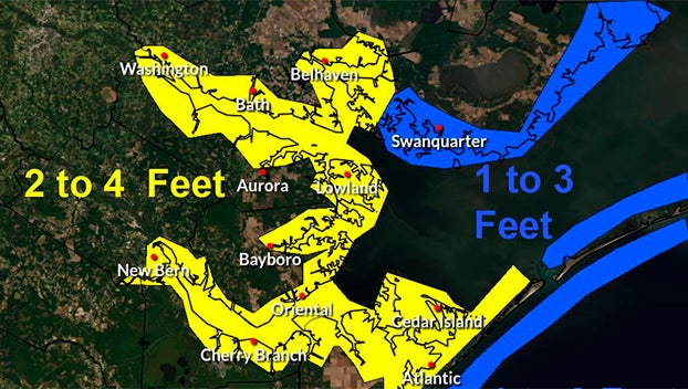
Storm Surge
- A Storm Surge Watch has been issued for Beaufort County’s waterways. Our coastlines are now forecasted to receive 2 to 4 feet of storm surge between noon Thursday and late Friday morning.
- Areas that are vulnerable to long durations of North / Northeast winds such as the western shoreline of the Pungo River and southern shoreline of the Pamlico River should prepare for at least 4 feet of surge during this time.
Severe Storms & Tornados
- As with many tropical weather systems, passing rain bands can result in severe thunderstorms capable of producing tornados. While severe storms are possible for all of Beaufort County through 9am Thursday, areas south and east of Belhaven, Bath and Blounts Creek will be at a slightly greater risk than other portions of our county.
Please see below and attached briefing from the National Weather Service for additional information.
From the National Weather Service, Morehead City:
We have added enhanced messaging regarding the increasing flood threat to our area, that will begin in a few hours and last from Tonight through Thursday afternoon.
We have increased rainfall totals and significant urban and flash flooding is expected which may prompt water rescues and even evacuations.
We have also issued a Coastal Flood Warning For Outer Banks Dare, with the impacts remaining the same.
NWS Morehead City Briefing #9 Idalia
More Weather


SportsPlus
How to Watch the WNBA Today | September 1
Today’s WNBA slate has five exciting matchups on the docket. Among those games is the Seattle Storm taking…
WNBA Betting Picks: Sunday, September 1
Need help with your wagers on today’s WNBA slate? Don’t worry. You’ll find computer predictions for the spread…
How to Watch MLB Baseball on Saturday, August 31: TV Channel, Live Streaming, Start Times
The Los Angeles Dodgers and the Arizona Diamondbacks square off in one of many compelling matchups on the…
How to Watch the WNBA Today | August 31
Today’s WNBA slate includes just one contest — the Connecticut Sun against the Washington Mystics. The WNBA is…
WNBA Betting Picks: Saturday, August 31
Wondering how you should bet on today’s WNBA game? Look no further. Below you’ll find computer predictions on…
-
Polls
 Loading ...
-
-