Tropical Storm Warning, Storm Surge Watch issued for Beaufort County
Published 11:45 am Thursday, September 21, 2023
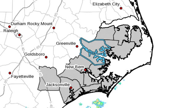
- (National Weather Service)
|
Getting your Trinity Audio player ready...
|
Potential Tropical Cyclone Sixteen Local Statement Advisory Number 1
National Weather Service Newport/Morehead City NC AL162023
1131 AM EDT Thu Sep 21 2023
This product covers Eastern North Carolina
**POTENTIAL TROPICAL CYCLONE 16 TO IMPACT EASTERN NORTH CAROLINA BEGINNING FRIDAY**
NEW INFORMATION
—————
* CHANGES TO WATCHES AND WARNINGS:
– A Tropical Storm Warning and Storm Surge Watch have been issued for Beaufort, Coastal Onslow, East Carteret, Hatteras Island, Mainland Dare, Mainland Hyde, Northern Outer Banks, Ocracoke Island, Pamlico, Southern Craven, Tyrrell, Washington, and West Carteret
– A Tropical Storm Warning has been issued for Inland Onslow, Jones, and Northern Craven
* CURRENT WATCHES AND WARNINGS:
– A Tropical Storm Warning and Storm Surge Watch are in effect for Beaufort, Coastal Onslow, East Carteret, Hatteras Island, Mainland Dare, Mainland Hyde, Northern Outer Banks, Ocracoke Island, Pamlico, Southern Craven, Tyrrell, Washington, and West Carteret
– A Tropical Storm Warning is in effect for Inland Onslow, Jones, and Northern Craven
* STORM INFORMATION:
– About 420 miles south of Morehead City NC or about 430 miles south-southeast of Jacksonville NC
– 28.7N 75.9W
– Storm Intensity 35 mph
– Movement North or 10 degrees at 9 mph
SITUATION OVERVIEW
——————
Potential Tropical Cyclone 16, currently east of the Florida peninsula, could strengthen as it moves toward eastern North Carolina over the next few days. Regardless of development, impacts will occur across eastern North Carolina, with greatest impacts along the coast.
Life threatening storm surge is possible across all coastal areas later Friday into the weekend. The most extensive impacts are expected to be along the lower Pamlico and Neuse Rivers, with at least minor overwash also possible along the Outer Banks.
Tropical storm force winds could start impacting portions of eastern North Carolina by early Friday morning with strong winds continuing through Saturday, potentially bringing scattered tree damage and power outages mainly along and east of Hwy 17.
Heavy rain bands could produce flash flooding of low lying areas with localized rainfall amounts near 6 inches expected near the coast.
Isolated tornadoes could produce locally significant damage mainly across the Inner and Outer Banks and Down East Carteret County.
Dangerous marine conditions are also expected with very dangerous surf conditions along the beaches.
POTENTIAL IMPACTS
—————–
* SURGE:
Protect against life-threatening surge having possible significant impacts across all of coastal eastern North Carolina north of Surf City.
Potential impacts in this area include:
– Areas of inundation with storm surge flooding accentuated by waves. Damage to several buildings, mainly near the coast.
– Sections of near-shore escape routes and secondary roads become weakened or washed out, especially in usually vulnerable low spots.
– Major beach erosion with heavy surf breaching dunes. Strong and numerous rip currents.
– Moderate damage to marinas, docks, boardwalks, and piers.
Several small craft broken away from moorings, especially in unprotected anchorages.
* WIND:
Protect against dangerous wind having possible significant impacts across the Outer Banks and Down East Carteret County. Potential impacts in this area include:
– Some damage to roofing and siding materials, along with damage to porches, awnings, carports, and sheds. A few buildings experiencing window, door, and garage door failures. Mobile homes damaged, especially if unanchored. Unsecured lightweight objects become dangerous projectiles.
– Several large trees snapped or uprooted, but with greater numbers in places where trees are shallow rooted. Several fences and roadway signs blown over.
– Some roads impassable from large debris, and more within urban or heavily wooded places. A few bridges, causeways, and access routes impassable.
– Scattered power and communications outages, but more prevalent in areas with above ground lines.
Also, protect against hazardous wind having possible limited impacts along and east of US Hwy 17.
* FLOODING RAIN:
Protect against dangerous rainfall flooding having possible significant impacts across Eastern North Carolina. Potential impacts include:
– Moderate rainfall flooding may prompt several evacuations and rescues.
– Rivers and tributaries may quickly become swollen with swifter currents and overspill their banks in a few places, especially in usually vulnerable spots. Small streams, creeks, canals, and ditches overflow.
– Flood waters can enter some structures or weaken foundations. Several places may experience expanded areas of rapid inundation at underpasses, low-lying spots, and poor drainage areas. Some streets and parking lots take on moving water as storm drains and retention ponds overflow. Driving conditions become hazardous. Some road and bridge closures.
* TORNADOES:
Protect against a tornado event having possible limited impacts across the Outer and Inner Banks and Down East Carteret County.
Potential impacts include:
– The occurrence of isolated tornadoes can hinder the execution of emergency plans during tropical events.
– A few places may experience tornado damage, along with power and communications disruptions.
– Locations could realize roofs peeled off buildings, chimneys toppled, mobile homes pushed off foundations or overturned, large tree tops and branches snapped off, shallow-rooted trees knocked over, moving vehicles blown off roads, and small boats pulled from moorings.
Elsewhere across Eastern North Carolina, little to no impact is anticipated.
* OTHER COASTAL HAZARDS:
Very dangerous marine conditions will occur across all area waters beginning Friday. Life threatening rip currents and surf conditions will also continue through the weekend.
PRECAUTIONARY/PREPAREDNESS ACTIONS
———————————-
* EVACUATIONS:
Listen to local official for recommended preparedness actions, including possible evacuation. If ordered to evacuate, do so immediately.
For those not under evacuation orders, assess the risk from wind, falling trees, and flooding at your location. If you decide to move, relocate to a safer location nearby. If you do not relocate, help keep roadways open for those under evacuation orders.
* OTHER PREPAREDNESS INFORMATION:
Now is the time to complete all preparations to protect life and property in accordance with your emergency plan. Ensure you are in a safe location before the onset of strong winds or possible flooding.
Keep cell phones well charged. Cell phone chargers for automobiles can be helpful, but be aware of your risk for deadly carbon monoxide poisoning if your car is left idling in a garage or other poorly ventilated area.
If you are a visitor, be sure to know the name of the city or town in which you are staying and the name of the county or parish in which it resides. Listen for these locations in local news updates. Pay attention for instructions from local authorities.
Closely monitor weather.gov, NOAA Weather radio or local news outlets for official storm information. Be ready to adapt to possible changes to the forecast. Ensure you have multiple ways to receive weather warnings.
* ADDITIONAL SOURCES OF INFORMATION:
– For information on appropriate preparations see ready.gov
– For information on creating an emergency plan see getagameplan.org
– For additional disaster preparedness information see redcross.org
NEXT UPDATE
———–
The next local statement will be issued by the National Weather Service in Newport/Morehead City NC around 5 PM EDT, or sooner if conditions warrant.
More Weather


SportsPlus
Buy Tickets for Carolina Hurricanes vs. Tampa Bay Lightning on October 11
The Carolina Hurricanes host the Tampa Bay Lightning on Friday, October 11 at 7:00 PM ET on ESPN+.…
How to Watch MLB Baseball on Saturday, Sept. 28: TV Channel, Live Streaming, Start Times
The New York Mets versus the Milwaukee Brewers is one of many solid options on today’s MLB slate.…
MLB Betting Lines and Picks Today | Sept. 28
Saturday’s MLB schedule has plenty of quality competition in store. Among those games is the New York Mets…
Best Bets, Odds for the Panthers vs. Bengals Game – Week 4
Check out best bets as the Cincinnati Bengals (0-3) will attempt to stop a three-game losing streak when…
Where to Watch East Carolina vs. UTSA on TV or Streaming Live – Sept. 28
On Saturday at 4:00 p.m. ET, the UTSA Roadrunners (2-2) will take on Jake Garcia and the East…
-
Polls
 Loading ...
-
-