Weekend weather conditions: Thursday evening update
Published 7:39 pm Thursday, September 21, 2023
- (National Weather Service)
|
Getting your Trinity Audio player ready...
|
From Chris Newkirk, Beaufort County Emergency Services:
This afternoon’s update included an increase is wind conditions Saturday morning, minor timing changes for other forecasted impacts as well as Tropical Storm and Storm Surge Warnings for Beaufort County. These changes have been highlighted in below.
Rain
- Rain will begin to move into the area around 8am Friday morning and continue through 1am Sunday. 2 to 3 inches of rain is expected for areas west of Bath and Blounts Creek during this time, with areas west receiving 3 to 4 inches.
- Our greatest chance of rain is currently forecasted to occur between 1pm Friday and 2pm Saturday.
- Our heaviest rains are expected to occur between 2am and 2pm Saturday.
Winds
- North and Northeast winds will begin to increase around 4am Friday morning becoming sustained between 20 and 25 mph with frequent gust of 25 to 30 mph by noon. These wind conditions are expected to continue 7am Saturday morning.
- The center of the storm is expected to be closest to our area between 9am and 11am Saturday morning. Sustained winds are expected to increase to 30+ mph with higher gust during this time.
- Winds will begin to transition to the West after 12pm Saturday and remain sustain between 15 and 20 mph with frequent gust of 20 to 30 mph through 2am Sunday morning.
- Areas that are adjacent to our county’s shorelines and vast open farm land will experience higher sustained winds and gust. (25 to 30 sustained with gust of 30 to 40 mph.)
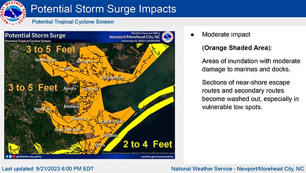
Storm Surge
Our waterways are now forecasted to receive 3 to 5 feet of storm surge between mid-day Friday and Saturday afternoon.
Please see below and attached briefing from the National Weather Service for additional information.
*For anyone planning to attend ECU’s home opener in Greenville on Saturday, the current game time forecast is as follows:
- Rain chances will begin to diminish around 1pm, with 1 tenth of an inch expected between 2pm and 7pm.
- Sustained west winds between 15 and 20 mph with gust of 20 to 25 mph are expected between 2pm and 10pm.*
From the National Weather Service, Morehead City
Attached is the 6:30 PM briefing on Potential Tropical Cyclone Sixteen. Tropical Storm Warnings have been expanded westward with this update. Storm Surge Warnings are now in place for inland rivers and portions of the mainland (see maps in briefing for details). A flood watch is also in effect for the entire forecast area.
Our biggest concerns remain the potential for storm surge, strong winds (especially near the coast and over the waters) and localized heavy rain. Refer to www.weather.gov/gov/tropical for more information.
NWS Morehead City Briefing #4 Potential Tropical Cyclone Sixteen
More Weather


SportsPlus
How to Watch MLB Baseball on Sunday, Sept. 29: TV Channel, Live Streaming, Start Times
Sunday’s MLB slate features the New York Mets playing the Milwaukee Brewers at American Family Field. Wager on…
How to live stream NFL RedZone Week 4 with a free Fubo trial
NFL fans, don’t miss a moment of the action during 4 in the NFL. Catch every touchdown from…
How to Watch the WNBA Playoffs Today | Sept. 29
The WNBA playoff schedule today, including the Las Vegas Aces versus the New York Liberty — one of…
WNBA Betting Picks: Sunday, Sept. 29
Need help with your wagers on today’s WNBA slate? Don’t worry. You’ll find computer predictions for the spread…
MLB Betting Lines and Picks Today | Sept. 29
The New York Mets versus the Milwaukee Brewers is a game to watch on a Sunday MLB slate…
-
Polls
 Loading ...
-
-