Tropical Storm Ophelia: Friday afternoon update
Published 4:54 pm Friday, September 22, 2023
|
Getting your Trinity Audio player ready...
|
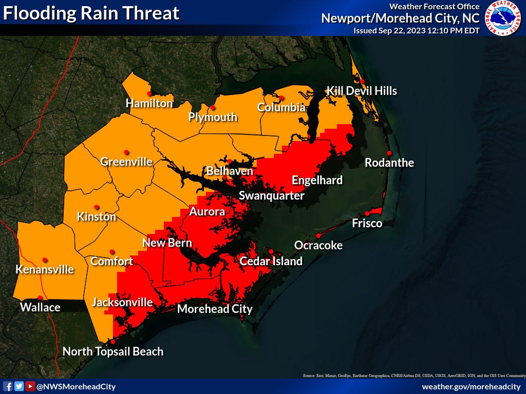
From Chris Newkirk, Beaufort County Emergency Services:
As you have probably already seen, the approaching tropical system has now become Tropical Storm Ophelia. The continued development of this storm has prompted the National Weather Service to continue to their updates beyond what was previously scheduled. Our office participated in a conference call moments ago with NWS staff and were advised that the 6:30pm update will most likely include the following changes for our area.
- Confidence is increasing that we will experience our highest winds tomorrow morning sometime between 7am and 11am. Gust of 45 to 60 mph will be possible during this time, especially along our shorelines and open land areas.
- Confidence has also increased that our waterways will experience the higher end of the currently forecasted storm surge values, with most areas likely receiving 5 +/- feet of surge. This will be particularly true for Belhaven, Pamlico Beach, Hickory Point, Washington and Chocowinity Bay. (Just for reference, 5’ has historically caused water to cover one lane of Whichard Beach Rd. in the curve between the railroad tracks and Twin Lakes Campground.)
While we certainly were hoping for less surge, we do not anticipate widespread issues with 5 to 6 feet. These impacts are normally localized to our low-lying areas that are known to be problematic. We also do not anticipate the forecasted surge conditions to cause widespread flooding in homes or waterfront communities. However, some of the homes will have water in their yards and perhaps crawlspaces or under elevated structures.
It would also not surprise us to see the 6:30pm update change our expected surge values from 3 to 5 feet to 4 to 6 feet.
More Weather


SportsPlus
How to Watch MLB Baseball on Saturday, August 31: TV Channel, Live Streaming, Start Times
The Los Angeles Dodgers and the Arizona Diamondbacks square off in one of many compelling matchups on the…
How to Watch the WNBA Today | August 31
Today’s WNBA slate includes just one contest — the Connecticut Sun against the Washington Mystics. The WNBA is…
WNBA Betting Picks: Saturday, August 31
Wondering how you should bet on today’s WNBA game? Look no further. Below you’ll find computer predictions on…
Where to Watch East Carolina vs. Norfolk State on TV or Streaming Live – August 31
The Norfolk State Spartans (0-1) will visit the East Carolina Pirates on Saturday at 6:00 p.m. ET. We…
Washington Mystics vs. Connecticut Sun Betting Odds and Matchup Preview – Saturday, August 31
The Washington Mystics (9-22) will try to build on a three-game winning streak when hosting the Connecticut Sun…
-
Polls
 Loading ...
-
-