Tropical Storm Ophelia: Friday evening update
Published 7:27 pm Friday, September 22, 2023
- (National Weather Service)
|
Getting your Trinity Audio player ready...
|
From Chris Newkirk, Beaufort County Emergency Services:
This evening’s update from the National Weather Service included a Hurricane Watch for the beach communities between Surf City and Ocracoke Inlet. It also increase the forecasted wind conditions, adjusted our storm surge values as previously discussed and made minor timing changes to our overall forecasted impacts. These changes have beenhighlighted below.
Rain
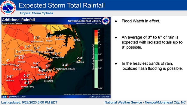
- Widespread rain is expected to continue through noon tomorrow, with most areas receiving 3 to 4 inches.
- Areas along and south of Hwy 33 may see locally higher amounts of 4 to 6 inches.
- Our heaviest rains are expected to occur between 9pm tonight and 8am tomorrow morning.
Winds
- North and Northeast winds are expected to be sustained between 15 and 25 mph with frequent gust of 25 to 35 mph through 6am tomorrow morning.
- Our highest winds are expected to occur between 7am and 11am tomorrow morning, as the center of the storm passes by our area.
- Areas along and west of Bath and Blounts Creek should expect to experience sustained winds of 35 to 40 mph with frequent guts of 45 to 55.
- Areas west, are forecasted to receive sustained winds of 45 to 55 mph with frequent gust of 65 to 75.
- This will be especially true for our waterfront and open land areas.
- Winds will begin to transition to the West and Southwest around 1pm Saturday and remain sustain between 15 and 20 mph with frequent gust of 20 to 30 mph through midnight Saturday.
Storm Surge
Our waterways are now forecasted to receive 4 to 6 feet of storm surge, with most areas receiving around 5 feet. Surge heights are expected to be at their highest between midnight tonight and noon tomorrow.
*For anyone planning to attend ECU’s home opener in Greenville on Saturday, the current game time forecast is as follows:
- Greenville is expected to receive its heaviest rains between 9pm tonight and 8am Saturday morning. Rain chances will begin to diminish around 2pm, with less than a tenth of an inch expected after 3pm.
- Sustained southwest winds between 10 and 20 mph with gust of 20 to 30 mph are expected between 3pm and 10pm.*
This will be the final update pertaining to this storm system. We encourage everyone to monitor your local media outlets for additional information and we ask that you assist us by ensuring you, your family, friends, and neighbors have a way of being alerted to any watches and / or warnings that may be issued during the overnight hours tonight.
From the National Weather Service, Morehead City:
Attached is the final planned briefing on Tropical Storm Ophelia. A Hurricane Watch is now in effect from Surf City to Ocracoke Inlet. Storm surge warning is now in effect for the rest of Carteret County. Conditions are expected to continue to deteriorate overnight with greatest impacts expected Saturday morning.
Refer to www.weather.gov/mhx/tropical for more information.
NWS Morehead City Briefing #7 Tropical Storm Ophelia
More Weather


SportsPlus
How to Watch MLB Baseball on Saturday, August 31: TV Channel, Live Streaming, Start Times
The Los Angeles Dodgers and the Arizona Diamondbacks square off in one of many compelling matchups on the…
How to Watch the WNBA Today | August 31
Today’s WNBA slate includes just one contest — the Connecticut Sun against the Washington Mystics. The WNBA is…
WNBA Betting Picks: Saturday, August 31
Wondering how you should bet on today’s WNBA game? Look no further. Below you’ll find computer predictions on…
Where to Watch East Carolina vs. Norfolk State on TV or Streaming Live – August 31
The Norfolk State Spartans (0-1) will visit the East Carolina Pirates on Saturday at 6:00 p.m. ET. We…
Washington Mystics vs. Connecticut Sun Betting Odds and Matchup Preview – Saturday, August 31
The Washington Mystics (9-22) will try to build on a three-game winning streak when hosting the Connecticut Sun…
-
Polls
 Loading ...
-
-