Hazardous weekend weather: Friday afternoon update
Published 3:39 pm Friday, December 15, 2023
|
Getting your Trinity Audio player ready...
|
From Chris Newkirk, Beaufort County Emergency Services:
More details are beginning to emerge regarding the impacts of this weekend’s weather. As previously mentioned, current forecast details are eerily similar to the conditions that were experienced during Ophelia last September. Changes to our local forecast have been highlighted below.
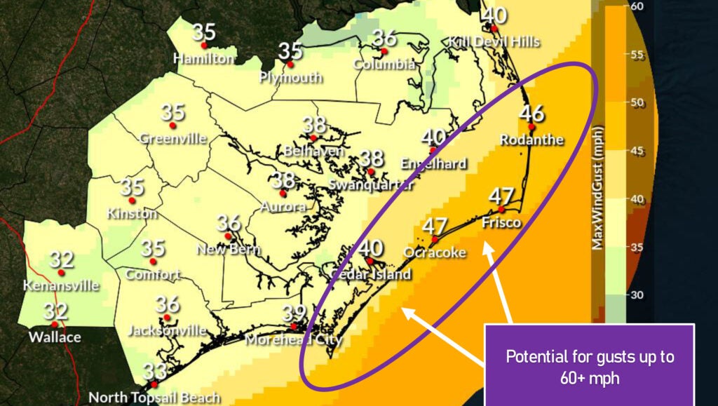
Current Forecast for Beaufort County
Rain
- Rain chances will increase after sunrise Sunday and continue through noon on Monday, with most areas currently forecasted to receive 2 to 3 inches.
- Areas along and east of Aurora and Pamlico Beach could recieve 3 to 4 inches.
- Our heaviest rains are currently expected to occur between 1pm and 7pm Sunday afternoon.
Winds
- Our forecasted winds will transition through various intensities and direction as follows:
- Sunday 8a – 2pm: East winds sustained between 10 and 15 mph with frequent gust of 20 to 25 mph.
- Sunday 3pm – 11pm: SE winds sustained between 20 and 25 mph with frequent gust of 30 to 35 mph.
- Monday 12am – 2am: South winds between 15 and 20 mph with frequent gust of 25 to 30 mph.
- Monday 3am – 8am: SW winds sustained between 15 and 20 mph with frequent gust of 30 to 35 mph.
- Monday 9am –4 pm: W winds sustained between 15 and 20 mph with frequent gust of 25 to 30 mph.
Flooding
- A Coastal Flood Watch has been issued for Beaufort County, meaning that moderate to major coastal flooding is possible for our county’s waterfront areas.
- Heavy rains along with elevated South and SE winds that will push water up the Pamlico River are expected to create a flooding hazard for shoreline and low-lying areas on Sunday and continuing through early Monday morning. Again, our current forecast is similar to many areas of our county experienced during Ophelia last September. If this forecast remains true, we anticipate the levels along our waterways to quickly rise after 8am Sunday morning and continue through the daylight hours. That increased water level would most likely remain through the early am hours on Monday before subsiding.
Thing To Consider And Watch For
- This continues to be a dynamic and evolving weather system. While forecast clarity and confidence is increasing, our expected conditions could change depending on the exact track and strength of this developing system. We are encouraging everyone that experienced flooding during Ophelia to utilize today and tomorrow to make the appropriate preparation efforts for similar impacts again.
- Continued Increasing Wind and Gust Values – Forecast trends continue to suggest that sustained winds and gust values for our area could continue to increase in future updates. This is a critical variable to monitor given Sunday’s east and SE wind conditions. The higher the winds received from that direction, the more impact it will have on our coastal flooding conditions.
- Surge / Inundation Values – We anticipate surge / inundation values of 3 to 5 feet to be included in this afternoon’s NWS update. However, these values could change for better or worse depending on the exact track and strength of this storm.
NWS Morehead City – Hazards Briefing #3 – Strong Low Dec 17 and 18
More Weather


SportsPlus
Hawks vs. Hornets Injury Report Today – October 25
Here’s a look at the injury report for the Atlanta Hawks (1-0), which currently has four players listed,…
Will Sebastian Aho Score a Goal Against the Flames on October 24?
Will Sebastian Aho score a goal when the Carolina Hurricanes face off against the Calgary Flames on Thursday…
Will Martin Necas Score a Goal Against the Flames on October 24?
On Thursday at 9:00 PM ET, the Carolina Hurricanes go head to head against the Calgary Flames. Is…
Will Andrei Svechnikov Score a Goal Against the Flames on October 24?
Should you wager on Andrei Svechnikov to light the lamp when the Carolina Hurricanes and the Calgary Flames…
Will Seth Jarvis Score a Goal Against the Flames on October 24?
For people looking to wager on the upcoming battle between the Carolina Hurricanes and the Calgary Flames on…
-
Polls
 Loading ...
-
-