Severe weather: Sunday afternoon update
Published 5:10 pm Sunday, December 17, 2023
|
Getting your Trinity Audio player ready...
|
From Beaufort County Emergency Services:
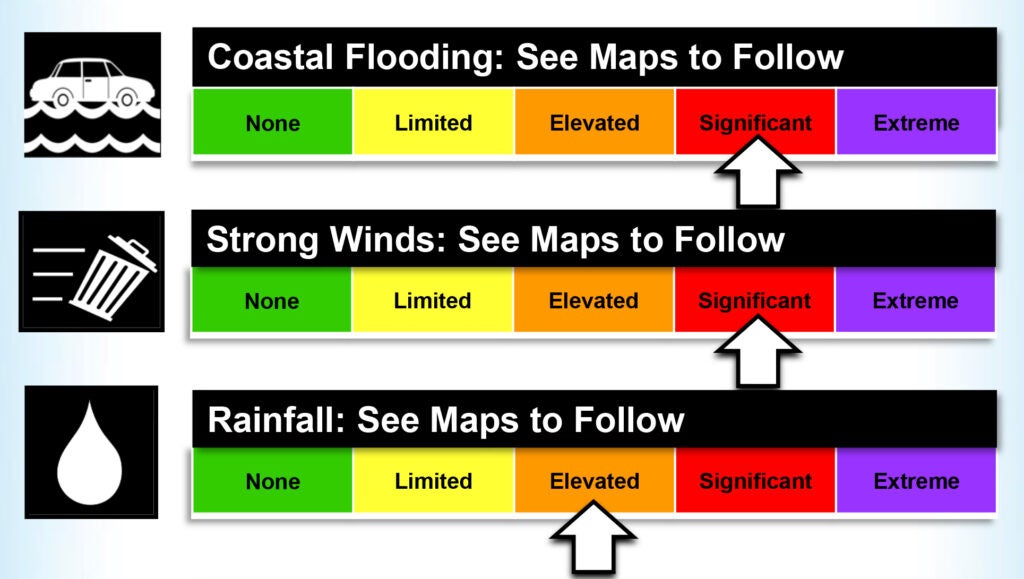
We would like to take a moment to brief you all on the information shared during this afternoon’s webinar with the National Weather Service. While we have been blessed with better-than-expected conditions so far, confidence remains high that we will experience the previously forecasted impacts as we move through the afternoon and evening hours. These impacts continue to include:
- 3 to 6 feet of water above normally dry ground along our county’s waterways.
- These flooding conditions are expected to peak between 7pm and midnight tonight and remain elevated through sunrise tomorrow.
- Sustained winds between 15 and 25 mph with gust of 30 to 40 are expected through sunset tomorrow.
- A tornado watch is now in effect for Beaufort County, and isolated tornados are also possible with this passing system. This will be especially true between 5pm this afternoon and 2am tomorrow morning.
- 3 to 4 inches of rain is expected, with locally higher amounts of 6” possible.
Hazardous conditions during the overnight hours often present with their own set of unique challenges. We encourage everyone to ensure that you have a means of being notified to watches and / or warnings that may be issued for your area. We recommend devices such as weather alert radios and / or phone apps with push notifications that can wake you up.
Please use the link below to view a recording of this afternoon’s NWS webinar.
https://youtu.be/sptUu8s5ImA?si=zV9rCBTyI5SL1z0U
More Weather


SportsPlus
Hawks vs. Hornets Injury Report Today – October 25
Here’s a look at the injury report for the Atlanta Hawks (1-0), which currently has four players listed,…
Will Sebastian Aho Score a Goal Against the Flames on October 24?
Will Sebastian Aho score a goal when the Carolina Hurricanes face off against the Calgary Flames on Thursday…
Will Martin Necas Score a Goal Against the Flames on October 24?
On Thursday at 9:00 PM ET, the Carolina Hurricanes go head to head against the Calgary Flames. Is…
Will Andrei Svechnikov Score a Goal Against the Flames on October 24?
Should you wager on Andrei Svechnikov to light the lamp when the Carolina Hurricanes and the Calgary Flames…
Will Seth Jarvis Score a Goal Against the Flames on October 24?
For people looking to wager on the upcoming battle between the Carolina Hurricanes and the Calgary Flames on…
-
Polls
 Loading ...
-
-