Severe weather potential Tuesday-Wednesday
Published 8:27 pm Sunday, January 7, 2024
|
Getting your Trinity Audio player ready...
|
From Chris Newkirk, Beaufort County Emergency Services:
Our office is continuing to monitor an approaching cold front that is expected to bring high winds, elevated water levels, rain and the potential for severe storms to our area Tuesday and Wednesday. Forecast details for Beaufort County can be found below.
Winds
- Our winds are forecasted to transition through numerous directions and intensities as follows:
- 8a – 3pm Tuesday: SE winds will begin to increase around 8am, becoming sustained between 20 and 25 mph with gust of 30 to 40 possible.
- 4pm – 11pm Tuesday: South winds sustained between 30 and 35mph with gust of 40 to 50 possible.
- Midnight Tuesday – 8am Wednesday: SW winds sustained between 15 and 25 mph with gust of 25 to 35 possible.
- 8am – 5pm Wednesday: West winds sustained between 15 and 25 mph with gust of 20 to 30 possible.
- Our highest winds are forecasted to occur between 5pm and 11pm Tuesday.
Flooding
- A Coastal Flood Watch has been issued for Beaufort County, meaning flooding in low-lying areas are possible within the next 48 to 72 hrs.
- 2 to 4 feet of surge is currently forecasted for our county’s waterways. This will be especially true for our northern shorelines areas that are vulnerable to sustained southerly winds, such as Belhaven and other communities along the Pungo River.
- Note: River gauges near Belhaven reported about 4 ½ feet of water rise during the storm that occurred a few weeks ago.
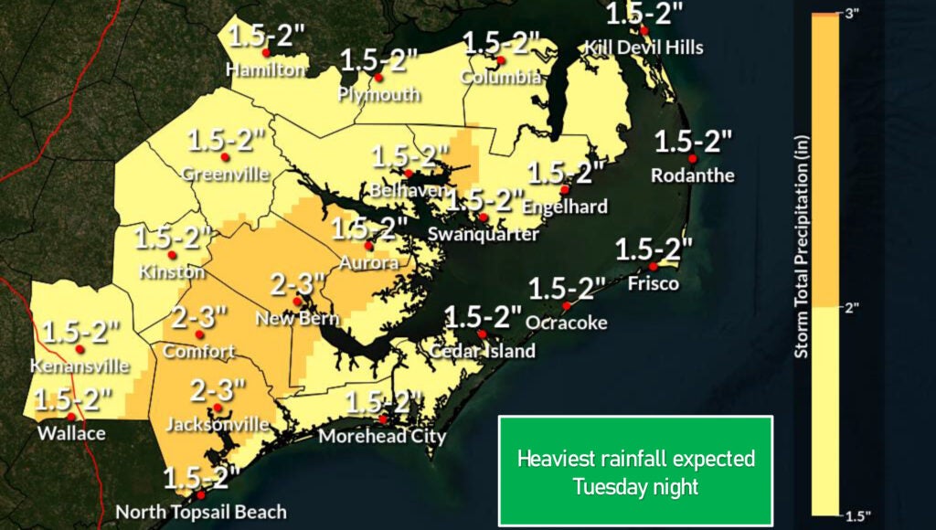
Rain
- Rain chances will begin to increase after 8am Tuesday, with rain likely for most areas by noon. Widespread rain is forecasted to continue through midnight Tuesday with most areas expected to receive 1 ½ to 2 inches during that time.
- Our heaviest rains are expected to occur between 7pm and midnight Tuesday.
Severe Storms
- Severe storms capable of producing heavy rains, dangerous winds and isolated tornados are possible as the cold front passes through our area between 7pm and midnight on Tuesday.
Please see below and attached briefing from the National Weather Service for more information.
From the National Weather Service, Morehead City:
There is high confidence that a strong cold front will impact the area Tuesday and Wednesday, bringing multiple hazards to eastern NC. Strong winds and the potential for moderate to locally significant coastal flooding are the primary concerns. Other impacts include, the potential for severe weather and very dangerous marine conditions.
NWS Morehead City Briefing #3 – Strong cold front Jan 9-10th, 2024
More Weather


SportsPlus
How to Watch MLB Baseball on Sunday, Sept. 29: TV Channel, Live Streaming, Start Times
Sunday’s MLB slate features the New York Mets playing the Milwaukee Brewers at American Family Field. Wager on…
How to live stream NFL RedZone Week 4 with a free Fubo trial
NFL fans, don’t miss a moment of the action during 4 in the NFL. Catch every touchdown from…
How to Watch the WNBA Playoffs Today | Sept. 29
The WNBA playoff schedule today, including the Las Vegas Aces versus the New York Liberty — one of…
WNBA Betting Picks: Sunday, Sept. 29
Need help with your wagers on today’s WNBA slate? Don’t worry. You’ll find computer predictions for the spread…
MLB Betting Lines and Picks Today | Sept. 29
The New York Mets versus the Milwaukee Brewers is a game to watch on a Sunday MLB slate…
-
Polls
 Loading ...
-
-