Elevated threat of severe weather Tuesday-Wednesday
Published 11:41 am Monday, January 8, 2024
|
Getting your Trinity Audio player ready...
|
From Chris Newkirk, Beaufort County Emergency Services:
This morning’s update from the National Weather Service (NWS) included an elevated threat of severe weather, to include the possibility of tornados, as well as an increase in the forecasted wind conditions. These changes / additions have been highlighted below.
Winds
- Our winds are forecasted to transition through numerous directions and intensities as follows:
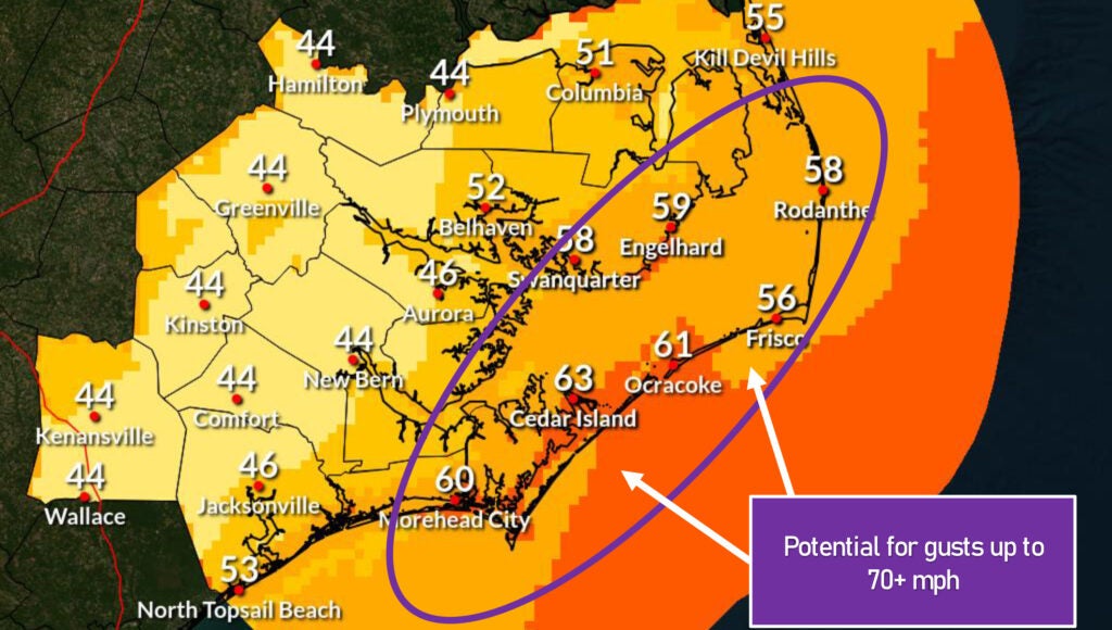
- 8a – 2pm Tuesday: SE winds will begin to increase around 8am, becoming sustained between 15and 25 mph with gust of 30 to 45 possible.
- 3pm – 11pm Tuesday: South winds sustained between 20 and 35mph with gust of 40 to 55possible.
- Midnight Tuesday – 5am Wednesday: SW winds sustained between 15 and 25 mph with gust of30 to 40 possible.
- 6am – 6pm Wednesday: West winds sustained between 10 and 25 mph with gust of 25 to 35possible.
- Our highest winds are forecasted to occur between 4pm and 9pm Tuesday as the strongest part of the cold front passes through our area.
Flooding
- A Coastal Flood Warning has been issued for Beaufort County, meaning coastal flooding is imminent.
- Our water levels are expected to begin to rise by mid-morning Tuesday and remain elevated through midnight. Water levels should begin to subside during the early morning hours on Wednesday as our winds begin to transition from the west.
- 2 to 4 feet of surge is currently forecasted for our county’s waterways. This will be especially true for our northern shorelines areas that are vulnerable to sustained southerly winds, such as Belhaven and other communities along the Pungo River.
- Here are few things to help put our flood risk into context.
- River gauges near Belhaven reported about 4 ½ feet of water rise during the storm that occurred a few weeks ago.
- Generally speaking, our county tolerates surge amounts of 4 feet or less relatively well, with localized issues only, to include water on our commonly impacted low-lying roadways in areas such as Belhaven, Pamlico Beach, Whichards Beach Rd, etc. While 4 feet of surge can be inconvenient, it generally does not cause widespread water damage to buildings. However, these impacts can quickly change as we approach 5 feet and beyond. Water at these levels can quickly create significant travel and access hazards associated with flooded roadways, and damage structures. Therefore, it will be imperative that we continue to monitor the forecasted wind conditions for Tuesday. Additional increases to the intensity of Tuesday’s SE and South winds will have the potential to increase our expected surge values. (This will be especially true for communities along the Pungo River.)
Rain
- Rain chances will begin to increase after 8am Tuesday, with rain likely for most areas by 1pm. Widespread rain is forecasted to continue through midnight Tuesday with most areas expected to receive 1 ½ to 2 inches during that time.
- Our heaviest rains are expected to occur between 7pm and midnight Tuesday.
Severe Storms
- This morning’s update has included Beaufort County in an “Enhanced Risk” category for severe weather. This is a rare designation that we believe to have only occurred twice in the past 6 years. Both of those occurrences resulted in significant straight-line wind and / or tornado damage to parts of our county.
- Severe storms capable of producing heavy rains, dangerous winds and isolated tornados are possible as the cold front passes through our area between 7pm and midnight on Tuesday.
Please see below and attached briefing from the National Weather Service for more information.
From National Weather Service, Morehead City:
Attached is the latest briefing for a strong cold front that will impact eastern NC tomorrow and Wednesday. The primary concerns are:
– Very strong winds and attendant moderate to locally significant coastal flooding
– Severe storms with the potential for significant damaging winds as well as a few tornadoes
– Dangerous marine conditions
More Weather


SportsPlus
How to Watch MLB Baseball on Saturday, July 27: TV Channel, Live Streaming, Start Times
The MLB slate today, which includes the Cleveland Guardians versus the Philadelphia Phillies, should provide some fireworks. Wager…
How to Watch MLB Baseball on Friday, July 26: TV Channel, Live Streaming, Start Times
The Cleveland Guardians versus the Philadelphia Phillies is a game to watch on a Friday MLB schedule that…
Carolina Panthers vs. Arizona Cardinals Week 16 Tickets Available – Sunday, December 22 at Bank of America Stadium
On Sunday, December 22, 2024, the Arizona Cardinals (0-0) meet the Carolina Panthers (0-0) at Bank of America…
Carolina Panthers vs. Dallas Cowboys Week 15 Tickets Available – Sunday, December 15 at Bank of America Stadium
The Dallas Cowboys (0-0) travel to Bank of America Stadium on Sunday, December 15, 2024 to take on…
Carolina Panthers vs. Philadelphia Eagles Week 14 Tickets Available – Sunday, December 8 at Lincoln Financial Field
On Sunday, December 8, 2024, the Philadelphia Eagles (0-0) and the Carolina Panthers (0-0) clash at Lincoln Financial…
-
Polls
 Loading ...
-
-