Severe weather potential Friday-Saturday
Published 5:19 pm Thursday, January 11, 2024
|
Getting your Trinity Audio player ready...
|
From Chris Newkirk, Beaufort County Emergency Services:
This afternoon’s update included minor changes to the timing of this weekend’s impacts and forecasted wind values. These changes have been highlighted below.
Rain
- Rain chances will increase after 5pm Friday and continue through 2am, with most areas currently forecasted to receive ¼ to ½” of an inch.
- Our heaviest rains are expected to occur between 8p and midnight.
Winds
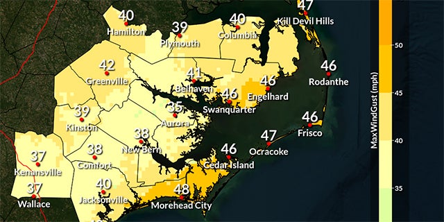
- Our forecasted winds will transition through various intensities and direction as follows:
- Friday 1pm – 8pm: SE winds sustained between 10 and 20 mph with frequent gust of 20 to30 mph.
- Friday 9pm – Saturday 1am: South winds sustained between 20 and 25 mph with frequent gusts of 30 to 40 mph.
- Saturday 2am – 6am: SW winds between 20 and 25 mph with frequent gusts of 30 to 35 mph.
- Saturday 7am – Sunday 9am: West winds sustained between 15 and 20 mph with frequent gusts of 20 to 30 mph.
Flooding
- Most of our county’s shoreline communities will experience 10 to 12 hrs of slightly elevated water levels (1ft+ above normally dry ground) Friday evening as we endure SE and south winds.
- Water levels will then reverse and be below normal on Saturday as west winds pull water from most of our waterways.
Severe Storms
- Severe thunderstorms capable of producing damaging winds and isolated tornados will be possible between 7pm and 3am Saturday.
- Our greatest chance of receiving severe weather will be between 10pm and 2am.
What To Watch For
- The National Weather Service has medium confidence in this evolving forecast, and many of the detail remain uncertain. Therefore, it is important that we monitor the continuation of recent trends by paying particular attention to the following potentials:
- Increasing wind gust values.
- Increase risk of severe weather.
Please see below and attached briefing from the National Weather Service (NWS) for additional information.
From the National Weather Service, Morehead City:
We are expecting strong to locally severe thunderstorms, gusty winds of 45-50 mph (coastal counties), and dangerous marine conditions for Eastern NC Friday Night (January 12th). A wind advisory has been issued for many coastal counties.
At this time, we are not expecting much in the way of coastal flooding, as the duration and marginal nature of southwesterly gales is quite brief. Water levels could reach as high as 1 foot above normal.
NWS Morehead City Briefing #2 – Strong cold front Jan 12th, 2024 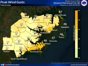
More Weather


SportsPlus
How to Watch MLB Baseball on Saturday, August 31: TV Channel, Live Streaming, Start Times
The Los Angeles Dodgers and the Arizona Diamondbacks square off in one of many compelling matchups on the…
How to Watch the WNBA Today | August 31
Today’s WNBA slate includes just one contest — the Connecticut Sun against the Washington Mystics. The WNBA is…
WNBA Betting Picks: Saturday, August 31
Wondering how you should bet on today’s WNBA game? Look no further. Below you’ll find computer predictions on…
Where to Watch East Carolina vs. Norfolk State on TV or Streaming Live – August 31
The Norfolk State Spartans (0-1) will visit the East Carolina Pirates on Saturday at 6:00 p.m. ET. We…
Washington Mystics vs. Connecticut Sun Betting Odds and Matchup Preview – Saturday, August 31
The Washington Mystics (9-22) will try to build on a three-game winning streak when hosting the Connecticut Sun…
-
Polls
 Loading ...
-
-