Today’s severe weather potential update
Published 10:29 am Friday, January 12, 2024
|
Getting your Trinity Audio player ready...
|
From Chris Newkirk, Beaufort County Emergency Services:
This morning’s update included very minor changes to timing of today’s forecasted impacts. These changes have been highlighted below.
Rain
- Rain chances will increase after 5pm Friday and continue through 2am, with most areas currently forecasted to receive ¼ to ½” of an inch.
- Our heaviest rains are expected to occur between 8p and 11pm.
Winds
- Our forecasted winds will transition through various intensities and direction as follows:
- Friday 1pm – 8pm: SE winds sustained between 10 and 20 mph with frequent gust of 20 to 30 mph.
- Friday 9pm – Saturday 1am: South winds sustained between 20 and 25 mph with frequent gusts of 30 to 40 mph.
- Saturday 2am – 6am: SW winds between 15 and 25 mph with frequent gusts of 25 to 35 mph.
- Saturday 7am – 7pm: West winds sustained between 15 and 20 mph with frequent gusts of 20 to 30 mph.
Water Levels
- Most of our county’s shoreline communities will experience 10 to 12 hrs of slightly elevated water levels (about 1 ft higher than normal) Friday evening as we endure SE and south winds.
- Water levels will then reverse and be below normal on Saturday as west winds pull water from most of our waterways.
Severe Storms
- Severe thunderstorms capable of producing damaging winds and isolated tornados will be possible between 6pm today and 1am Saturday.
- Our greatest chance of receiving severe weather will be between 8pm and 11pm.
Please see below and attached briefing from the National Weather Service (NWS) for additional information.
We encourage everyone to take a moment today to ensure that you, your family , friends and neighbors have a means of being notified to any storm warnings that may be issued during this event. This could include tuning into local media outlets, weather radios, push notifications from weather monitoring phone apps, etc.
From the National Weather Service, Morehead City:
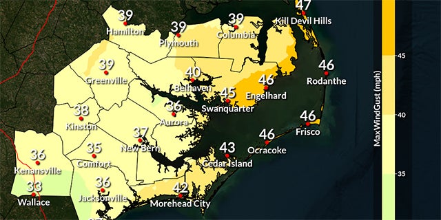
We are expecting strong to severe thunderstorms, gusty winds of 35-50 mph (highest for coastal counties), and dangerous marine conditions for Eastern NC tonight (January 12th). A wind advisoryremains in effect for many coastal counties.
We are not expecting impactful coastal flooding, as the duration of southwesterly low-end gales is quite brief. Water levels could reach as high as 1 foot above normal.
NWS Morehead City Briefing #3 – Strong cold front Jan 12th, 2024
More Weather


SportsPlus
How to Watch the WNBA Today | August 31
Today’s WNBA slate includes just one contest — the Connecticut Sun against the Washington Mystics. The WNBA is…
WNBA Betting Picks: Saturday, August 31
Wondering how you should bet on today’s WNBA game? Look no further. Below you’ll find computer predictions on…
Where to Watch East Carolina vs. Norfolk State on TV or Streaming Live – August 31
The Norfolk State Spartans (0-1) will visit the East Carolina Pirates on Saturday at 6:00 p.m. ET. We…
Washington Mystics vs. Connecticut Sun Betting Odds and Matchup Preview – Saturday, August 31
The Washington Mystics (9-22) will try to build on a three-game winning streak when hosting the Connecticut Sun…
Where to Watch Washington Mystics vs. Connecticut Sun on TV or Streaming Live – Saturday, August 31
The Washington Mystics (9-22) will try to extend a three-game winning stretch when hosting the Connecticut Sun (22-8)…
-
Polls
 Loading ...
-
-