Rain, severe weather potential for Saturday
Published 1:32 pm Friday, March 8, 2024
|
Getting your Trinity Audio player ready...
|
Our office is currently monitoring the forecast of an approaching frontal system moving through this weekend that could produce heavy rainfall, isolated strong to severe thunderstorms and strong winds. The current forecast for Beaufort County includes:
Rain
- Rain chances will increase after midnight and continue through Sunday morning, with most areas currently forecasted to receive 1” to 1.5” of rainfall.
- Our heaviest rains are currently expected to occur between 9am Saturday morning and 7pm Saturday evening.
Winds
- Our forecasted winds will transition through various intensities and direction as follows:
- Saturday 9am – 12am: West winds between 10 and 15 mph with frequent gusts of 30 to 40 mph.
- Saturday 12am – Sunday 9am: West winds sustained between 10 and 15 mph with frequent gusts of 20-25 mph.
Flooding
- Periods of heavy rain could cause flooding to the low-lying areas of Beaufort County.
Severe Storms
- Possible severe thunderstorms could affect the County starting at 2pm Saturday, with the peak of the storms from 3pm Saturday to 12 am Sunday morning.
What To Watch For
- Again, there are a lot of factors playing into the forecast of this approaching system and many of the details remain unclear. We encourage everyone to pay particular attention to the following potentials:
- Increasing Wind Gust Values – The latest forecast trends suggest that wind gusts could increase for our area, with some models referencing gusts ranging between 30 and 40 mph for Saturday afternoon going into early Sunday morning.
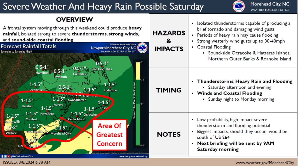
Please see below and attached briefing from the National Weather Service (NWS) for additional information.
From the National Weather Service, Newport/Morehead City:
A frontal system impacting our area this weekend is capable of bringing strong to marginally severe thunderstorms, heavy rainfall, strong wind gusts, and sound-side coastal flooding.
Heavy Rain and Thunderstorms capable of producing a brief tornado and damaging wind gusts are possible Saturday afternoon and evening. Strong westerly winds will result in elevated water levels for sound-side Outer Banks north of Ocracoke Inlet Sunday night into Monday morning.
This is a low probability, moderate/high impact event. There are many uncertainties with this weather system. We will send out the next briefing with more information by 9AM Saturday.
NWS Morehead City Frontal System 1 Pager #1 March 9 2024
More Weather


SportsPlus
How to Watch MLB Baseball on Saturday, August 31: TV Channel, Live Streaming, Start Times
The Los Angeles Dodgers and the Arizona Diamondbacks square off in one of many compelling matchups on the…
How to Watch the WNBA Today | August 31
Today’s WNBA slate includes just one contest — the Connecticut Sun against the Washington Mystics. The WNBA is…
WNBA Betting Picks: Saturday, August 31
Wondering how you should bet on today’s WNBA game? Look no further. Below you’ll find computer predictions on…
Where to Watch East Carolina vs. Norfolk State on TV or Streaming Live – August 31
The Norfolk State Spartans (0-1) will visit the East Carolina Pirates on Saturday at 6:00 p.m. ET. We…
Washington Mystics vs. Connecticut Sun Betting Odds and Matchup Preview – Saturday, August 31
The Washington Mystics (9-22) will try to build on a three-game winning streak when hosting the Connecticut Sun…
-
Polls
 Loading ...
-
-